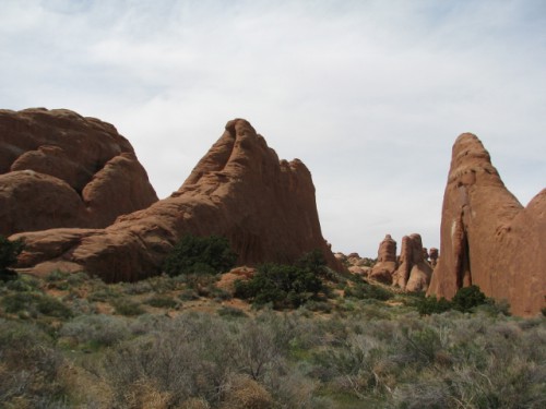
After we checked out Cliff Palace, we headed over to Balcony House to meet the rangers for the tour.
The rangers at the Visitor’s Center had let us know that we would need to be climbing ladders, crawling through tight spaces, and climbing up on the original foot holds of the original inhabitants, so understandably, the tour begins with the safety talk. They give more warnings and encourage anybody who has concerns about their abilities to reconsider whether this tour is a good idea. It is a necessary beginning, because they certainly don’t want to have to deal with someone who can’t make the climb, or becomes paralyzed by fear, or gets stuck in the tight space in the tunnel.
Ranger Wendell did have a bit of humor for us though, telling us that one of her fellow rangers shoots for a 90% return rate on tour participants. That’s 90% returning home from the tour; not 90% who return to the park for another tour!
Ranger Clyde led our tour of Balcony House; he wasn’t wearing his uniform that day but I’m not sure why. But, as it turns out, we were in for a real treat. Ranger Clyde is a Navajo historian in addition to being a Park Ranger, so he provided a unique perspective on the sacred nature of the dwelling.
We walked down the steps to get below the mesa top, and Ranger Clyde began the tour talking about the things in nature that the Native Americans used to make their world easier. The plants that they used to make clothing, shoes and bedding, the animals that they ate and used for household purposes, and the ways that they navigated their environment to survive. He encouraged us to look around at the landscape and see what plants and animals could be used, and what their purpose would be.
Ranger Clyde showed us a seep, where the water would flow down through the sandstone and emerge in a little pool near the entrance of the dwelling. This water gave the Puebloans one of the key elements of survival. Even though Mesa Verde gets only about 10 inches of rain per year, there are numerous seeps that provide water year round.
Then we started up the ladder. This ladder didn’t exist during the period when the Puebloans inhabited the dwelling – when we climbed up the 35 foot ladder we weren’t climbing up to the original entrance of the dwelling either. The ladder was a very sturdy double ladder, installed by the Park Service in the 1930s, and even though it was quite tall, I was perfectly comfortable climbing up. There was just a very brief period where I got a little bit nervous about the height as I was getting off at the top.

The ladder to enter Balcony House – you can see the dwelling above
Once you are at the top of the ladder, you are in the cliff alcove where Balcony House is built. To get into the dwelling, you have to squeeze through a tight space between the back of the overhang in the cliff and the stone wall constructed by the Puebloans. This tight squeeze turned out to be fairly large when you consider what comes later. At this point we were in the dwelling, which is 40 rooms. Balcony House is considered a medium sized cliff dwelling in terms of the size of dwellings at Mesa Verde. Only 10 cliff dwelling sites at Mesa Verde have more rooms. The alcove itself is 264 feet long, 20 feet high and 39 feet deep, so they made good use of the space.

Balcony House – with one of the two kivas in the foreground
Balcony House is some of the last construction at Mesa Verde; it was built between 1180 and 1270 A.D. The dwelling is also one of the least accessible sites at Mesa Verde. The only access for the Puebloan people was down the steep mesa cliff, with hand and foot holds carved or worn into the sandstone over time. Although very little is known about the inhabitants here, archaeologists have made some educated guesses about why Balcony House was constructed somewhat differently than most other cliff dwellings in the area.

Balcony House and its retaining wall
It is believed that relationships between the communities in the Four Corners region may have deteriorated to the point where security in the dwelling was a concern. They believe that may be why Balcony House was built with such a secure entrance. When you are inside Balcony House, it is easy to see that the Puebloans used all available space. They built walls back into the overhang, and all the way up to the ceiling. There is evidence that the dwelling was 3 stories tall in some areas. You can see where the mortar still clings to the back and sides of the cliff overhang, and also where soot from fires stained the overhang black over a hundred years.
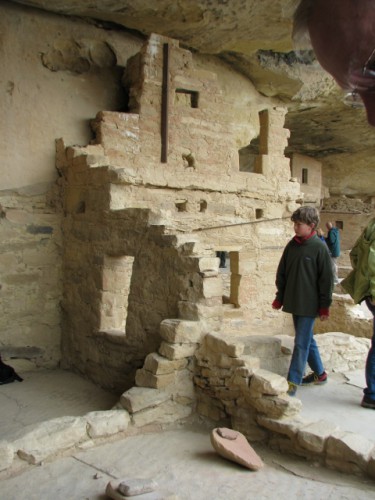
More of Balcony House – in this photo you can see one of the steel support bars (to the left of the two small windows on the second story) that was installed during the restoration in 1910. It is not considered good historic preservation now, but the Park Service has let the old structural supports stay.
Balcony House is named for the balconies that exist between the first and second stories of the rooms. These overhangs were used by the inhabitants to move from one second floor room to another. They may have also been used as work spaces. The fact that these balconies still exist with their original 800 year old wooden beams and adobe mortar is amazing. In some rooms, wooden beams up high near the ceiling are thought to be drying racks.

Me inside Balcony House – you can see the one of the balconies that the dwelling is named for. And please pay no attention to my mismatched outfit – it was cold that day and I had to wear all of my warm clothes!
After we finished up our tour, there is still the process of getting out. The original entrance to Balcony House is what the Park Service uses as an exit – a 12 foot long roofed tunnel built by the original inhabitants. Short people like me can duck walk through the tunnel, but taller people have to crawl to get through it. Either way, it is a tight squeeze – they recommend taking off your backpack to get through if you are wearing one.
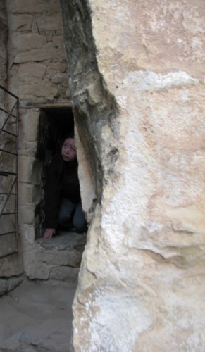
The original entrance tunnel to Balcony House – could you fit?
Once we were outside of Balcony House, we made our way back up to the mesa top using the hand and foot holds that the Puebloan people used when they lived here. The Park Service has enlarged them and installed a fence that will keep most people from falling (unless you tumble over the fence), but the journey up the cliff was still a bit scary for me. Let’s just say I did not look down!

The climb back up to the mesa top from Balcony House. There are no statistics on how many of the Puebloan people died in falls.
I loved our tour! It was fascinating to see just how tough these people were and to experience just a tiny bit of how they would have lived. It was well worth challenging my fear of heights yet again!
Have you toured Balcony House? Are you brave enough to want to?