Day 6 – August 6, 2015.
Our Colorado trip so far had been filled with National Parks, but today we made plans to do something a bit different! We instead headed out to go to St. Elmo, Colorado – a ghost town!
On the way, we made quick stops at two historic schoolhouses. The Nathrop School was built in 1881, and had a lovely bell tower. The story goes that the bell was cast in St. Louis, Missouri, and had to be melted down and recast three times before it created a suitable ring – one that could be heard for miles. The Nathrop School closed in 1946.

Historic one-room schoolhouse in Nathrop, Colorado, built 1881.
The Gas Creek School was built in 1890, and was used as a school until 1942. It is unique because it features separate doors for boys and girls, and has a huge Cottonwood tree in its front yard. It is now privately owned; it is located on Highway 285, between Salida and Nathrop.

Historic Gas Creek schoolhouse outside of Salida, Colorado. Built 1890.
After the schoolhouses, we made our way up a small mountain road to St. Elmo. The road begins as a paved two lane country road, but eventually becomes gravel – that said, it is a smooth, well-maintained gravel road. St. Elmo was a mining town; it was founded in 1880, and most of the surviving buildings in the town are from 1881 – 1882. It sits at an altitude of 9,961 feet. Silver and gold were both mined here, and for a while, it was extremely profitable. The longest running mine – the Mary Murphy, operated until 1922 and mined an estimated $60,000,000 in gold.

The General Store in St. Elmo
‘As is the case with most mining operations, eventually the ore gave out and the community began to dry up and die away. St. Elmo began declining significantly after the departure of the railroad line feeding the town in 1922; the last residents finally gave up the ghost in the 1950s. St. Elmo was listed as a Historic District on the National Register for Historic Places in 1979.

Historic buildings in St. Elmo

An old filling station in St. Elmo
The unique thing about St. Elmo is its state of preservation – the buildings are maintained here in a state of decay, but not restored. There are also many more buildings than you will find in most ghost towns. St. Elmo today has some homes that are used as summer homes, and some year-round residents operate a general store and an Inn, but that is the extent of its current business presence – it is very much a ghost town. Jeeps and ATVs use the old mining trails for off-road adventures, and fishing is popular in the area as well.

Jon and me, in St. Elmo

Three old buildings in St. Elmo.

An old home in St. Elmo

The historic St. Elmo Schoolhouse, built 1882

An old outhouse in St. Elmo
We spent about an hour wandering around taking photos of all the old buildings; there is an old school, shops and stores, and lots of homes. St. Elmo also has a different kind of summer resident – hummingbirds. I think they were Broad-Tailed Hummingbirds. I was able to get some good photos of them, thanks to the feeders put up by the owners of the general store.
-

- Two Broad-Tailed Hummingbirds
-

- Two Broad-Tailed Hummingbirds
-

- A Broad-Tailed Hummingbird
-

- A Broad-Tailed Hummingbird
We also saw tons of Least Chipmunks and several Wyoming Ground Squirrels – the Chipmunks have been conditioned to eat sunflower seeds right out of your hand. I didn’t feed them myself, because I don’t like to contribute to the taming of wild animals – it just causes too many issues when they become acclimated to and dependent on humans. But I have to admit I took photos of them begging for seeds and clambering around the pile of sunflower shells, because they were pretty cute. I got a nice photo of two Ravens sitting on a fence too.
-

- One very pudgy chipmunk
-

- A Wyoming Ground Squirrel looking for seeds
-

- Least Chipmunk enjoying a sunflower seed
-

- Common Ravens sit on a fence in St. Elmo
-

- What’s that? I have something on my chin, you say?
After our fill of cute animals and old buildings, we got back on the road to Leadville! We passed a couple more historic one-room schoolhouses, and Jon and his parents humored me by letting me get pictures.
The Maxwell School (also known as the Mt. Princeton School) was built in 1889, and used until 1933. It was made with handmade concrete blocks – if you look closely at the blocks you can see the hand and fingerprints – unfortunately that kind of detail doesn’t really show up in the photos. It has been stabilized, and there have been attempts to preserve it – the roof has been replaced and so have the windows, although it is currently boarded up to protect it from vandals.
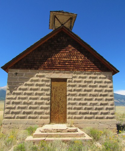
The Maxwell School, also known as the Mt. Princeton School, outside of Buena Vista, Colorado. Built in 1889; closed in 1933.
I could not find any information on this old red school outside of Leadville, except that it may have been built in 1902, but I love its bell tower and bright color. It has clearly been painted somewhat recently.

Old Leadville School – perhaps built 1902.
We were almost to Leadville and I was starving! I’ll tell you about Leadville next!