Archives

Joshua Tree 2015: A Rock Like a Skull!

My last day at Joshua Tree National Park was a half day, as I needed to get back to the airport and fly home.

I visited one of the most iconic rock formations – Skull Rock.  It really does look like a skull, with eye sockets and a nose and everything.  The area around Skull Rock has lots of fun rocks to climb on, and I took an opportunity to climb around with all the other tourists.

Skull Rock

Skull Rock


Me with Skull Rock

Me with Skull Rock

Then I went over to Hidden Valley, which has a short one-mile nature walk through the rock formations.  Hidden Valley is so named because it was rumored to have been a place where cattle rustlers hid the cattle that they had stolen from nearby ranchers.  The location of the valley and its rock formations also made for a slightly cooler environment than other areas of the desert, meaning that it has a different ecosystem.  Oak, juniper and grasses grow here among the rocks.

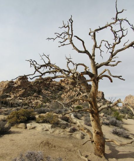
A dead tree frames the rock formations in Hidden Valley

A dead tree frames the rock formations in Hidden Valley

The Hidden Valley Trail gave me one last opportunity to walk among and climb on the rocks.  It is a great trail for kids; an easy loop.

Me perched on a rock in Hidden Valley

Me perched on a rock in Hidden Valley


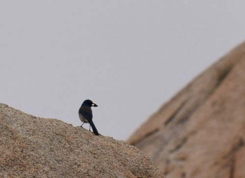
A raven stands watch at Joshua Tree

A raven stands watch at Joshua Tree


The raven takes off from his perch.

The raven takes off from his perch.

Hidden Valley is also an area where people try their hand (or feet!) at tightrope walking.  I was able to watch a few people walk across a line stretched between two rocks about 50 feet above the ground.  It looked terrifying!  It was really neat to watch, although I hope they were tethered with safety lines…  It looks like there’s one in the photos; I hope so!

A tightrope walker at Hidden Valley

A tightrope walker at Hidden Valley

All in all, I really enjoyed my time at Joshua Tree.  Even though it wasn’t really warm, the sun was shining and there was no rain!  What a fabulous long weekend!

Joshua Tree 2015: Gold and Horse Thieves

Day 2: December 6, 2015

Keys View

First thing in the morning I drove up to Keys View – a viewpoint within the park that offers 360 views of the desert and several unique features. Palm Springs and the Coachella Valley are visible below, and I got a great view of the Salton Sea in the distance. Smog often conceals the view of Mexico, but the wind must have blown the smog away that morning, because I was able to see Signal Mountain, about 95 miles away, across the border to Mexico. It was a great view!

The view of the Coachella Valley

The view of the Coachella Valley


The Salton Sea, with Signal Mountain - 95 miles away in Mexico - in the top, distant center.

The Salton Sea, with Signal Mountain – 95 miles away in Mexico – in the top, distant center.

It was really cold though – the wind and exposed location made me glad that I had brought my hat and gloves! Winter in the desert can be cold, especially at higher elevations, and it wasn’t even a particularly cold day!

Lost Horse Mine – 4 miles RT

The Lost Horse Mine is aptly named. In 1890, Johnny Lang and his father brought their cattle to the Lost Horse Valley for grazing. One night, their horses disappeared, and they were able to track them to near the Keys Ranch, where they had a run-in with the McHaney Brothers, suspected cattle rustlers. The McHaneys told them their horses weren’t there.

Looking down on the Lost Horse Mine Trail.

Looking down on the Lost Horse Mine Trail.

Along the way, Lang made the acquaintance of another man, who had discovered gold in the area, but was afraid to develop the mine because of threats by the McHaneys. He sold his claim to Lang, who acquired three partners to offer protection, and started developing the mine. He purchased a two stamp mill, hauled it up the hill, and set up a line to bring steam up the hill to power the mine. The work was difficult; due to the remoteness of the site, a road had to be built to haul all the materials through several miles of undeveloped desert.

Mining Equipment at the Lost Horse Mine.

Mining Equipment at the Lost Horse Mine.

Unlike many other mines in the area, the Lost Horse mine was very successful. Eventually, Lang partnered with a Montana businessman, who brought a larger ten stamp mill to the site. Of course, at some point he realized that Johnny Lang was skimming profits off the top, as the day shift and the night shift were producing very different amounts of gold. He gave Lang the option to either be bought out or go to jail. Lang chose the buy-out, and kept prospecting nearby, until he died of exposure one winter. His body wasn’t found for a couple of months, and then was buried near Keys View Drive.

Some sort of gears overlooking the Lost Horse Mine.

Some sort of gears overlooking the Lost Horse Mine.

The Lost Horse Mine produced more than 10,000 ounces of gold and 16,000 of silver, more than $5 million in today’s dollars, over its lifetime. Not too shabby!

The head frame of the Lost Horse Mine.

The head frame of the Lost Horse Mine.

The hike is an out and back, two miles uphill on the way out and downhill on the way back. It is a moderate hike, with views of the valley and a recent forest fire, as well as rock foundation ruins of various cabins and outbuildings in the area.

The view from the Lost Horse Mine

The view from the Lost Horse Mine

The mine threatened to cave in several years ago; the National Park Service tried a new innovative technique that involved filling the mine shafts with polyurethane foam, and then covering the foam with fill dirt to prevent it from disintegrating in the sun. They also built a new head frame over the main entrance to the mine. Despite all this however, the mine is still unstable, so there is a fence around the main entrance to prevent people from walking too close to the shaft.

The head frame of the Lost Horse Mine.

The head frame of the Lost Horse Mine.

After checking out the mine, I also hiked up to the top of the hill for a 360 view of the surrounding area. It was beautiful! I saw a small, orange butterfly there as well, he was such a pretty little guy! On the return hike I saw a small lizard, the only one I saw during my trip. Most of the reptiles in the park are in a state of hibernation in winter, so it isn’t typical to see them unless the temperatures are sufficiently warm.

A butterfly at the Lost Horse Mine.

A butterfly at the Lost Horse Mine.


A lizard on the Lost Horse Mine Trail.

A lizard on the Lost Horse Mine Trail.

After the Lost Horse Mine, I drove over to the boundary where the Mojave Desert meets the Colorado Desert. Near this spot is a place where the habitat is perfect for a type of cactus, the Teddy Bear Cholla. The name is misleading though, as the cholla is covered in thousands of tiny, hair-like spines that will quickly attach and then embed themselves under your skin, making for a very painful experience. This one area of the park has a “garden” of hundreds of cholla, making it look like they were intentionally planted here.

Teddy Bear Cholla

Teddy Bear Cholla

The walk in the cholla garden is not rigorous, and gives visitors a good overview of how these cacti grow and reproduce. There are even birds that love to nest in the cholla, because the spines give them protection from predators! A short distance away from the cholla garden, the desert provides habitat for ocotillo, a succulent that has long thin leaves stretching high over my head. These plants can appear dead for much of the year, coming back to life and blooming after a rain.

Ocotillo

Ocotillo

My evening included a trip for more pho; this time at the Red Lotus in Twenty-Nine Palms.  It was kind of fun to compare the pho at each place.  I liked the broth at the Yucca Valley pho restaurant better, but I liked the meat better here.  It was a good end to another good day.


Joshua Tree 2015: A Failed Quest for Bighorn Sheep

In December, I flew down to Los Angeles for a quick long weekend trip to Joshua Tree National Park. It was not extensively planned; tickets were booked just a couple of weeks before. But despite that, it was a fabulous trip.

Day 1: December 5, 2015

Willow Hole Trail – 7 miles RT

The first day I started at the Visitor’s Center for some trips on where to go in the park. I wanted to see Bighorn Sheep. The Ranger said that they often hung out at the Willow Hole, which can be reached by a 7 mile round trip hike through several dry washes that connect to the popular Boy Scout Trail. I went. The trail was mostly flat, taking you by a popular rock climbing area; it was fun to stop and watch the climbers try their trade on the giant boulders in the park.

Me on the Willow Hole Trail

Me on the Boy Scout Trail


Joshua Trees everywhere!

Joshua Trees everywhere!


There are climbers on that rock!

There are climbers on that rock!

After leaving the Boy Scout Trail, I was entirely alone – I did not run into anyone else on the entire hike. It was quiet, save for the birds chirping, letting me know I was getting closer to the spring. Sadly, I did not see any Bighorn Sheep on the hike, but I saw some songbirds and it was a nice pleasant hike nonetheless.

A cute bird near Willow Hole

A cute bird near Willow Hole


The clouds gave way to sunshine

The clouds gave way to sunshine

Barker Dam – 1 mile RT

Barker Dam is a dam that was built by homesteaders in the early 1900s, to provide a consistent water source for their cattle grazing in the area. The dam is still there – the National Park Service left it intact when they took over management of the land, and it now provides water for the wildlife living in the area. It is another spot that Bighorn Sheep are known to frequent in the park. Except when I was there; then the Bighorn Sheep are not…

Barker Dam

Barker Dam

The Barker Dam hike also leads past several ancient petroglyphs. Unfortunately, they have been damaged by vandals. They are still neat to see, but keep in mind that the paint colors and outlines were the result of the vandalism, and not what these petroglyphs would normally look like.

Petroglyphs near Barker Dam

Petroglyphs near Barker Dam

As I was finishing the short Barker Dam trail, the sun was sinking lower in the sky. The birds and the rabbits were finding their way to their shelters for the night. I was able to find a good vantage point along the main road to watch the sunset. It wasn’t a spectacular viewpoint, but it did let me get some photos of the Joshua Trees silhouetted against the setting sun.

The golden light before sunset

The golden light before sunset


The sun sets over Joshua Trees...

The sun sets over Joshua Trees…

Dinner that night was pho at Pho 85 restaurant in Yucca Valley. It really hit the spot after 8+ miles of hiking that day! I finished off the day with some wine and TV in the room before heading to bed.  Peace…

Joshua Tree National Park History

The Yucca brevifolia makes its home within the unique habitat of the Mojave Desert in Joshua Tree National Park.  More commonly known as a Joshua Tree, this yucca was named by Mormon pioneers who believed that these succulents looked like the biblical figure of Joshua raising his arms to heaven in prayer.

Joshua Trees!

Joshua Trees!

Joshua Tree National Park protects two primary desert habitats, the cooler higher elevation Mohave Desert, located between 2,000 and 5,000 feet in elevation, and the hotter Colorado Desert (part of the larger Sonoran Desert) at the lower elevations.  The Mojave Desert is known for its Joshua Trees, while the Colorado Desert has cholla and ocotillo.

Joshua Tree National Park

Joshua Tree National Park

Joshua Tree also has several spectacular rock formations, which are monzogranite, created when groundwater seeped into cracks in the monzogranite and eroded the corners away to form the round rocks.  Then when flash floods eroded away the ground around the rocks, these large rounded boulders were left exposed.  The exposed piles of rocks are called inselbergs.  Joshua Tree became a mecca for winter rock climbing, when places like Yosemite were covered in snow.  However, it eventually became a destination in its own right.

Joshua Tree was designated as a National Monument in 1936, after Minerva Hoyt’s activism on behalf of preserving desert habitats achieved protection for the park.  Although she was originally born on a plantation in Mississippi, she moved as a young woman to Pasadena, California and became interested in desert plants through gardening.  Mrs. Hoyt was also instrumental in obtaining protection for Death Valley and the Anza-Borrego Desert.  The park was elevated to National Park status on October 31, 1994, after passage of the Desert Protection Act; at the same time 234,000 acres were added to the park for a total size of 790,636 acres (1,235.37 square miles).

In addition to rock-climbing, the park is popular for hiking, birding – hundreds of bird species travel through the park on their spring and fall migrations, and astronomy.  The park’s dark skies, along with Southern California’s relatively stable atmosphere, makes for excellent conditions for observing the stars.  The park has nine campgrounds for visitors, and annual visitation is 1,383,340.

The sun sets over Joshua Trees...

The sun sets over Joshua Trees…

Park wildlife includes many species of birds, lizards, snakes, rabbits, ground squirrels, coyotes and Bighorn Sheep.  Many of the animals within the park are nocturnal, due to the high daytime temperatures.  Native Americans inhabited the area beginning about 400 years ago, but were gone by the early 1900s.  Prospectors began moving into the area in the 1840s, looking for gold and silver.  Over time, about 300 mines were established within the current boundaries of the park – most didn’t produce much, but a few were quite profitable.  There are still several areas within the park where visitors can see the remnants of the old mines.

I was lucky enough to visit Joshua Tree for a long weekend in December, and I had a wonderful time.  My posts will be coming soon!