Archives

2014 Oregon Wine Country Half Marathon

Last year was the second year that I did the Oregon Wine Country Half marathon (when I tell you it was Labor Day weekend, you’ll know how far behind I am on posts!).  In 2013 it was just me and Shelley, but in 2014 I was able to sucker convince several friends to join in the fun! In all, it was me, Jon, Katie, Katy, Allysa, Angela, Renee and Jean. We all made our own way down to Oregon, because some of us were just staying the weekend, some were heading off on further adventures afterwards, and some were on the way back from vacationing! Jon and I drove separately, because Jon had to work on Monday afternoon, but we caravanned with Angela and Renée.

We met up at the Ponzi Wine Bistro in Dundee and enjoyed lunch and a bottle of Pinot Noir. Everybody was pleased with their choices; I had a delicious grass fed burger. The wine was fabulous, and it was wonderful to just be able to relax and laugh with good friends.

Jon and me having lunch at Ponzi, the day before the race.

Jon and me having lunch at Ponzi, the day before the race.

After that, we braved more of that terrible Highway 99 traffic to make our way to McMinnville for the packet pickup at the Evergreen Aviation Museum. After we got our packets, we sampled some wines from the two wineries that had tasting stations on site. More and more of us kept rolling in, so we chatted and laughed and enjoyed the bright sunshine outside the museum.

That evening, it was “do it yourself” dinner night – some went out for dinner, some just grabbed a quick bite at the diner next door to our hotel. Katie and I went to the grocery store and grabbed some eats for ourselves and families – Katie had come with her husband and two littles. A hodge podge of fruit, meats, cheeses and breads was the perfect pre-race dinner, in my opinion.

The race was very similar to the year before – I think there was one minor course change. For more info on the course and the mile by mile experience, check out my post from 2013. I feel good about my race; I came in fifth among my friends, behind Jon, Jean, Allysa and Katy, and in front of Katie, Angela and Renee. My time was a little slower than last year – a 3:03:08 (a 13:58 per mile pace).  Our finish order was exactly where I expected us all to be!

The Gang - Pre-race - at Stoller Winery

The Gang – Pre-race – at Stoller Winery

It was fun to see us all do it at our own pace and in our own way – we were competing with ourselves and not each other. I was about 5 minutes behind my personal best from the 2013 race, but I had been having a wee bit of trouble at the beginning with my shin splints, so while a little disappointing, it wasn’t surprising. I feel like I finished strong.

The post race festival was fabulous again – the group of us joined together and broke apart and joined together again, as we went to get wine, came back to compare notes, and went off again in search of the best wines to be had.  It was way too long ago to remember the specifics, but my post on the wine festival from last year should give you a good idea…  Lunch was again at the little sandwich shop – a fantastic Reuben.

Later in the afternoon, after getting a much needed shower and change of clothes, a group of us wandered around downtown McMinnville poking in shops, and enjoying some huckleberry ice cream.  Dinner that night at La Rambla (a tapas restaurant) ended a wonderful day. Good friends enjoying good food…

Wenatchee: Ohme Gardens

I went to a conference in Chelan last September, and Jon came over to meet me for the weekend. We had already been to Chelan, so we decided to stay about 30 minutes away in beautiful Wenatchee. We went to Ohme Gardens, which is a garden created by a couple on a rocky outcropping overlooking the city. Herman and Ruth Ohme got married in 1929, during the Depression, and really didn’t have any money, but they had purchased a 40 acre orchard property that included this plot of land high on a hill overlooking town.

It was arid, with scrub brush and no trees, but they stood on the dry outcropping and imagined something much more lush. They set about transforming it into an oasis in the desert. You may not know, but Wenatchee only gets 9 inches of rain per year, so creating a garden with plants from the Cascade Mountain range was quite the feat.

In the beginning, the couple would head out for the day to public lands, and dig up plants that they wanted to transplant to their garden. Don’t do this, by the way, it is illegal. But this was back then, and obviously nobody stopped them. Once they transplanted some plants, the hard work began. There was no irrigation system, so they had to drive a truck with barrels of water up as high as they could go, and then they hand watered the whole garden using buckets. Buckets! The garden was smaller in the beginning, but that’s a lot of tramping up and down the hill with a 5 gallon bucket of water…

Ohme Gardens eventually grew to the 7 acres that it is today, and has an irrigation system, multiple ponds, mature pine trees and sunny grassy areas. Due to its location on a steep slope, exploring it means climbing up and down the hill on a series of garden paths and stepping stones. Don’t wear heels… There are plenty of shady nooks and crannies to keep you relatively cool in the hot summer sun, and apparently it is a popular wedding venue.

When Mr. Ohme became too elderly to keep up the garden by himself, his children started helping, and Mr. Ohme died at the age of 80 in 1971.  In 1991, they donated the garden to the State, who eventually transferred it to Chelan County.  I would love to come back sometime when the spring flowers are blooming – I bought their tourist guide and the photos in springtime look amazing. And I had no idea this gem was even there!

I didn’t bring my larger camera, for some crazy reason, so the pictures didn’t turn out as nice as I would have hoped, but I hope you can tell how neat this place is. If you have a chance, go – it is certainly worth the $7 admission.


Nisqually National Wildlife Refuge in Winter

On the way home from Ridgefield National Wildlife Refuge, Jon and I stopped for a short visit at Nisqually National Wildlife Refuge. My mother and I had visited on the hottest day of July, when no animals in their right minds would be outside in the scorching sun.

This time, the refuge was transformed. The huge grass field from July was now under several inches of water, flooded by seasonal rainfall and the tidal system. There were ducks and geese all over, enjoying their winter feeding grounds. Visitors can look at the birds from the viewing platform, or can walk further out on the boardwalk. We did both, but there weren’t very many birds out further on the open water of the field. Plus, it was cold and windy (although not really raining), so we only took a brief walk before heading back to dry land.

A Great Blue Heron at Nisqually

A Great Blue Heron at Nisqually

On land and in the water close to shore were lots of American Wigeons, Mallards, and Canada Geese (or maybe Dusky Geese, who knows…).

There were lots of American Wigeons at Nisqually

There were lots of American Wigeons at Nisqually

This goose was having a great time eating or playing in the fluff of these reeds.

This goose was having a great time eating or playing in the fluff of these reeds.

I spotted a white bird far off in the distance – I wasn’t sure if it was a bird or a plastic bag at first (my far vision really is getting crummy these days – I blame my mom). I was able to zoom in and get a closer look (and some photos) at a white goose. I identified it later with my bird book and the internet – a Snow Goose! He was hanging around with several ducks, and it was odd to see him without any other Snow Geese. I hope he wasn’t injured…

The Lone Snow Goose on our visit.

The Lone Snow Goose on our visit.

We couldn’t hang out too long though, as we still had a long drive home.

Ridgefield National Wildlife Refuge

Ridgefield’s claim to fame, as near as I can tell, is the Sandhill Cranes that head through on the way to their winter grounds. They come through in November, and we tried to go then, but the weekend that Jon had off it was pouring down rain west of the Cascades, and pouring down snow in the Cascades. Coincidentally, this was pretty much the only snow that the mountains received all winter, but that’s a bit off topic…

So, convinced that it would be a waste of time and money to go see Sandhill Cranes, who would likely be hiding somewhere else, and even if they were out we wouldn’t be able to see them in the deluge, we postponed our trip to our next weekend off together. If you follow this blog, you know that Jon and I typically only get 3 days off together per month, so our next weekend off together was in December.

The weather was very rainy, but certainly no worse than a typical December day in the Pacific Northwest.  I wish I could have gotten better pictures, but it was a pretty dark day, so I did what I could.  As we expected, the Sandhill Cranes were already gone, having moved further south, but we did see lots of other cool birds.

A Great Blue Heron checking us out.

A Great Blue Heron checking us out.

A Great Blue Heron looking for its next meal.

A Great Blue Heron looking for its next meal.

Ironically, Ridgefield wasn’t created to protect the Sandhill Cranes, but rather the Dusky Geese, whose migratory landing spots in Alaska were destroyed by the earthquake and subsequent tsunami in 1964. Which just goes to show that there really is a big connection when you think about the living world.

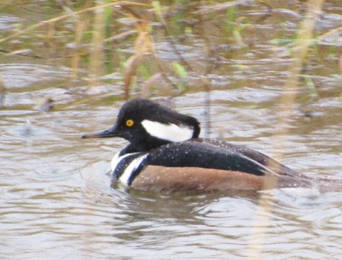
A Hooded Merganser at Ridgefield

A Hooded Merganser at Ridgefield

Dusky Geese look like shorter, smaller and slightly fatter Canada Geese to me, with a bit more blurred facial markings, and darker brown chests (that’s called a breast in the bird world). They are actually considered a subspecies of Canada Geese, along with several other subspecies, which are often so similar that even the experts have trouble telling them apart. Apparently, it’s a DNA thing. Which now leads me to wonder if all the Canada Geese I’ve been seeing my whole life are Canada Geese at all. But, if the experts can’t tell them apart, then they can’t really expect me to either.

Dusky Geese - They look a lot like Canada Geese to me.

Dusky Geese – They look a lot like Canada Geese to me.

And we saw nutria! If you don’t know what a nutria is, just imagine a giant rat crossed with a beaver. Or look at the picture below. The good thing about nutria is that a casual observer can tell them apart from rats and from beavers too. Nutria are native to South America, but of course, some moron 100 years ago decided it would be great to bring them here as pets, and then other morons decided it would be a good idea to release them into the wild when they turned out to not be such great pets, and the nutria decided that the climate of northern Oregon and Southern Washington is wonderful and set about eating their way through the marshes here. That’s the short version of what probably is a much longer story.

The first Nutria we saw at the refuge.

The first Nutria we saw at the refuge.

Nutria are actually pretty destructive, but here they are. We saw two that day, waist deep in the marsh, happily chewing vegetation in the rain without a care in the world. Of course, they might have been wondering if those geese over there were Canada Geese or Dusky Geese…

This is the second Nutria we saw - this photo shows his rat-like tail.

This is the second Nutria we saw – this photo shows his rat-like tail.

We also saw one hawk (I wasn’t able to get a great picture), three Blue Herons, and a gazillion Northern Pintails, Mallards, American Coots, Tundra Swans and the aforementioned Dusky Geese.

A hawk at Ridgefield - maybe a Red Tailed Hawk?

A hawk at Ridgefield – maybe a Red Tailed Hawk?

Tundra Swans - They like to do butts up too!

Tundra Swans – They like to do butts up too!

Despite the rain that fell the whole time we were there, and got all over the doors of the car and my camera when we had the windows open to take pictures, we had a good time. Jon’s favorite sighting of the day was the nutria, and I have to admit, I enjoyed seeing them too. I also liked seeing the Northern Pintails, especially when they go “butts up!”

A male Northern Pintail doing butts up!

A male Northern Pintail doing butts up!

Have you been to Ridgefield National Wildlife Refuge?  What was your favorite animal?

MI Road Trip: Wine in a Hospital

After visiting the Mission Point Lighthouse, we got back on the road and headed back toward town, deciding to stop along the way at Brys Estate Winery.  It was recommended by the server at Douglas Valley Winery, so I was curious to try it.  I was surprised by how large Brys Estate is – it started as a retirement project and the winery now produces several thousand cases annually. The tasting is unique – instead of bellying up to the tasting bar, they have visitors going through four different tasting stations.  It seemed like we were at a special event, but apparently that’s just how they do their tasting now.

Brys Estate Winery

Brys Estate Winery

At each station we chose between two wines; Jon and I selected different wines at each station so we could get to sample all of them.  The wines were all good, ranging from Rieslings to Cabernet Franc to Pinot Noir, but nothing stood out in my memory as amazing.  Their servers were all friendly and knowledgeable, but it was awkward at the end. After we finished at the last station, we ended up back in the main tasting room. If you want to buy wine, you have to find it yourself on their ‘wall o’ wine’, and it just seemed kind of impersonal.

The Brys Estate Outdoor Chairs - they would be heavenly on a cold day.

The Brys Estate Outdoor Chairs – they would be heavenly on a cold day.

We dropped by a brewery on the Old Mission Peninsula next, hoping to get some lunch and a beer, but the place was crawling and the wait was going to be 90 minutes! Umm… no thanks! So we headed back into town to see what we could find at our next stop, Grand Traverse Commons.

The Grand Traverse Commons is a large retail/housing development that redeveloped the old Traverse City State Hospital.  The hospital was founded in 1881, and opened to patients in 1885.  It was an asylum for patients with mental illnesses, although at times its mission was expanded to provide care for patients with tuberculosis, polio, influenza and diphtheria.

The Front of the Main Building at Grand Traverse Commons

The Front of the Main Building at Grand Traverse Commons

Many of the patients hospitalized there were able to function on varying levels – at the time it was commonplace to institutionalize people with mental illnesses that would not typically result in hospitalization today; illnesses like depression, bipolar disorder, post-partum depression or anxiety disorders.

Long before drug therapy was commonplace, the hospital set about to try to provide cutting edge therapy that helped people with mental illness be productive within the hospital. Restraint devices like straightjackets were prohibited. The first superintendent, Dr. James Decker Munson, developed a “beauty is therapy” program. He believed that beauty could be therapeutic, so the hospital had greenhouses to produce flowers year round. Additionally, he developed a farm that allowed the hospital to be self-sustaining, and also allowed many of the patients to have jobs that contributed to feelings of self-worth. The farm raised milk cows, beef cows, pigs, chickens and horses, and farmed vegetables.

The Spires of the Main Building at Grand Traverse Commons

The Spires of the Main Building at Grand Traverse Commons

The hospital population slowly declined due to the changes that came about in the mental health system that eliminated institutionalization as an option for all but the most severely affected individuals, and the Traverse City State Hospital closed its doors in 1989. Redevelopment came slowly, but Building 50 – the main administration building of the hospital, has now been redeveloped into a multi-use building, with shops, restaurants and condos.

We found an Italian restaurant called Trattoria Stella and got some lunch. I had the mushroom soup (fantastic!) and a risotto with fried egg, chives, sweet pea, rosemary, Parmesan and cream.  I had high hopes for the risotto but it was WAY too salty… I also had the Black Star Farms sparkling wine, and loved it. Jon had the minestrone soup (he loved it) and a beet salad with mozzarella, onions and kalamata olives that was delicious as well. He paired his with a Dark Horse Brewery Crooked Tree IPA. After lunch, we wandered around the grounds for a little while; Jon was a sport to let me take photos of the redeveloped buildings and the still abandoned ones, even though he was freezing.

Jon's Beet Salad at Trattoria Stella

Jon’s Beet Salad at Trattoria Stella

Features on an unrestored building at Grand Traverse Commons

Features on an unrestored building at Grand Traverse Commons

While we were at the Grand Traverse Commons, we decided to check out the Black Star Tasting room as well.  You could opt for a wine tasting or a distilled spirits tasting. I picked the wine, Jon picked the spirits. I found several that I enjoyed and ended up buying two wines to take home, including their Blushed sparkling wine. Jon purchased a bottle of craft Peninsula Gin from Grand Traverse Distillery.

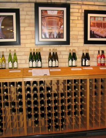
Wine Bottles at Black Star Farms Tasting Room

Wine Bottles at Black Star Farms Tasting Room

And with that, we made our way back to the car to find our way to my aunt and uncle’s house. We had a couple of hours of driving ahead of us, according to Google Maps, so I was a bit surprised to find that our GPS was telling me it would take almost 4 hours to get to my aunt’s house! There didn’t seem to be any traffic! I had been driving along in this state of confusion for almost a half an hour when I suddenly realized that the day before I had set the route preferences to avoid highways, so we could see the more scenic route. But now we wanted to go the more direct way. OOPS!

Once we changed the settings, our arrival time moved up significantly! We got to my aunt and uncle’s house just after the rest of the family finished up dinner, so we were able to get some food and spend some time catching up with the family. The next day there was a family reunion, but our brief tour of Michigan had drawn to a close…

MI Road Trip: Traverse City Eats and Lights

In my last post, we wrapped up with a gorgeous sunset from a viewpoint on the Pierce Stocking Scenic Drive at Sleeping Bear Dunes National Lakeshore.  It was about a 45 minute drive to Traverse City, so we ended up having a very late dinner at The Filling Station Brewery.  I had scoured the tourism magazines while Jon drove to find a brewery that also offered food.  By the time we got there, I was ready to chew my arm off!

The Filling Station is aptly named, because it resides in an old train station. It is decorated with a 1960s décor, with lots of bright orange plastic. To drink, Jon had the Walla Walla IPA, and I had the Long Lake Red Ale. For dinner, we split the Cannonball Flatbread and The Conductor salad. The Cannonball had marinara sauce, Kalamata olives, roasted red peppers, feta, red onions, fresh rosemary and mozzarella. The Conductor was made with artisan greens, cherry tomatoes, hard boiled eggs, prosciutto, red onion, blue cheese and a house made buttermilk ranch dressing. The food was delicious and really hit the spot after our challenging hike earlier.

The Conductor Salad at The Filling Station Brewery

The Conductor Salad at The Filling Station Brewery

We spent the night at the Travelodge in Traverse City.  They were overbooked for the night, so we ended up getting upgraded to what might have been the biggest room in any Travelodge ever!  It clearly had been the manager’s apartment at one point, and had a full kitchen, two bathrooms, a living room, a small alcove room with bunkbeds, and a bedroom, with a luxurious, memory foam mattress.  It was almost a shame to only be spending 12 hours there.

In the morning, we made our way out onto the Old Mission Peninsula. The peninsula is 19 miles long and 3 miles wide, dotted with fruit orchards, wineries and vineyards, and with a historic lighthouse smack-dab at the very end. My kind of place! The Mission Point Lighthouse was built in 1870 looking out at the West Grand Traverse Bay, as a result of a shipwreck in 1860 right in front of where the lighthouse now stands (the construction delay was due to the Civil War).

The View From the Old Mission Peninsula

The View From the Old Mission Peninsula

The lighthouse is 36 feet tall, but sits on a sand bank, which makes the light’s focal height 47 feet; it was lit with a Fifth Order Fresnel lens. The lighthouse was tended between 1870 and 1933 with a series of lighthouse keepers, and it is unusual because Mission Point had a woman lighthouse keeper! Sarah Lane tended the light with her husband Captain John Lane for 24 years, and she continued alone for almost four months after her husband died in December 1906.

The Mission Point Lighthouse

The Mission Point Lighthouse

In 1933, the lighthouse was decommissioned, with an automated light mounted nearby. Between 1933 and 1948, the lighthouse stood empty. The residents of Traverse City took up a collection and raised enough money for the city to purchase the lighthouse and the adjacent land. Over the years, caretakers lived there and restored it. And recently, the Coast Guard loaned the lighthouse a Fifth Order Fresnel lens to display (the original had been removed when the lighthouse closed in 1933). The Mission Point Lighthouse is on both the National and the State Historic Registers.

A Fifth Order Fresnel Lens on Display

A Fifth Order Fresnel Lens on Display

The lighthouse was open, with a small exhibit and gift shop on the first floor. For a modest donation, you can tour the upstairs (of course we did!).  Be sure to sign in to their guest book with your hometown; they receive grant money in larger amounts when visitors come from further away.  The second floor contains the bedroom of the keeper’s living quarters, with information about the keepers that served the lighthouse over the years. The top floor is accessed by a narrow, ladder staircase; once at the top you have a 360 degree view. The water is in front of the lighthouse and on one side and the other two sides have a forest view.

I enjoyed being at the top looking out, imagining what it would have been like when this was an isolated place. Although it was a cold day, it was very clear and peaceful.

The View from the Lighthouse

The View from the Lighthouse

After visiting the lighthouse, we also stopped by the Hessler log cabin, which was originally built between 1854 and 1856, by Joseph and Mary Hessler. Constructed from hemlock and white pine, it was a family home for several years, before being used throughout the years as a storage building, living quarters for cherry pickers, and a barn for a bull. It was moved to this location from elsewhere on the peninsula. You can peek inside and see how small the cabin is – it would have been interesting to live there as a family. It makes you appreciate the luxuries we enjoy today!

The Hessler Cabin at the Mission Point Lighthouse

The Hessler Cabin at the Mission Point Lighthouse

Of course, we couldn’t stay too long, because we had other places we wanted to visit!

Have you been to the Mission Point Lighthouse and climbed to the top?

MI Road Trip: A Scenic Drive and Children’s Story

Did you ever read the Pippi Longstocking books as a child?  The ones about the little girl with the braided pigtails, superhuman strength, and spotted horse?  I did.  And this blog has nothing to do with Pippi Longstocking, except…  Sleeping Bear Dunes National Lakeshore has a scenic drive called the Pierce Stocking Scenic Drive, which I will always remember as the Pippi Longstocking Scenic Drive!  There is absolutely no relation, except the slightly similar name that makes my imagination run wild.

The drive is named for Pierce Stocking, a local lumberman who began building the road in the 1960s.  He thought the area was so beautiful that he wanted to share it with people.  He charged $2 per car to drive the scenic road.  Stocking also built the covered bridge on the drive.  The scenic drive became part of the national park, and is now maintained by the park service along with the rest of Sleeping Bear Dunes.

After we made it back from The Dune Climb – and poured the sand out of our shoes – again… we decided to do the Pierce Stocking Scenic Drive. The light was really fading at that point, so I didn’t know how much we would see on the 7.4 mile drive.  But as it turns out, there is a beautiful, historic covered bridge right at the beginning, and we happened to find a deer grazing right near the bridge. The photo isn’t great, because it was dark, but I enjoy the memory.

Covered Bridge on Pierce Stocking Scenic Drive

Covered Bridge on Pierce Stocking Scenic Drive

The drive has 12 scenic viewpoints – one that looks over the dune that we had just been hiking on! It was interesting to see it from above – and to watch the last straggling hikers make their way home.  Other viewpoints give a view of Glen Lake, and the forest that makes up much of the scenic drive.

A view of the dunes, with North and South Manitou Islands in the background

A view of the dunes, with North and South Manitou Islands in the background

The next viewpoint we stopped at provided the best view ever. A wooden walkway leads you out onto a platform overlooking a bluff with a 450 foot drop down to Lake Michigan.  Looking out over the water, we watched the most amazing hot pink and orange sunset. The colors were spectacular, reflecting on a lake that sparkled like glittering diamonds. Wow – I was completely at peace, except for the ever dropping wind chill.

A spectacular Lake Michigan Sunset!

A spectacular Lake Michigan Sunset!

After the sun dropped below the horizon and my camera’s batteries died (probably because I took so many pictures of that amazing sunset!), I was walking back down the short path to the car. Jon had gone ahead because he was cold. There wasn’t much light left, so I stopped when I saw an animal that looked like a raccoon emerge from the woods and start walking to the parking lot.

After cautiously following it for a minute, I realized it was a porcupine! It was the first time I’ve ever seen a porcupine in the wild! I didn’t get any photos, but it was really neat to see.  When we got to the parking lot, he crawled under somebody’s car, hung out for a minute, then scooted out the other side back into the woods.

And Jon and I headed towards our final destination for the night – Traverse City!

Have you driven the Pierce Stocking Scenic Drive? 

MI Road Trip: The Dune Climb!

Have you ever hiked over 4 miles of sand dune?  We did, and I tell you, it was a really great workout!  After visiting historic Glen Haven and the Life Saving Station at Sleeping Bear Dunes National Lakeshore, we were itching to get more physical with nature.

The Dune Climb starts off with just that – a climb up a very large sand dune. It is huge – the people near the top look like little ants. We heard you could hike all the way to the lake – a round trip of 3.8 miles (we took a little detour, so we went more than 4), but we weren’t really sure what to expect. So we started climbing, in the soft, fine sand – perfect sand for a beach! It was tough to climb in – I started feeling it almost right away!

The beginning of The Dune Climb

The beginning of The Dune Climb

We stopped a couple of times on the way up the hill to look back at the view – a gorgeous view of the forest and a nearby lake – picture perfect. I could have stood there for hours just looking at that view (you will see this is a theme for this hike)…

The view of Glen Lake from the top of the first dune

The view of Glen Lake from the top of the first dune

When we got to the top of the hill, the dune flattened out and did a couple of gradual ups and downs. So we kept going.  Peaks and valleys of sand, one after another; we were only able to see the hill immediately coming up in our path. We started finding wooden markers with numbers; we hadn’t noticed them before. The crowd thinned out, and we found ourselves hiking through the loose sand with almost no one else around.

We had been hiking about 45 minutes and had just passed a marker with the number 11 on it when we came upon a group coming back from the other direction. A young lady explained that we just had to get to marker 27 and we’d be at the lake. My heart sank – we were less than halfway – which seemed to mean at least another hour to get there. I thought about turning back, but Jon really wanted to go all the way… What we didn’t know then is that I’m positive that the markers are NOT equidistant (do I get bonus points for using the word equidistant in this blog?).

Up one hill, down another… This is a very strenuous hike, due to the fact that you are always on a hill, and you are hiking in soft sand. But we made it to the lake, with the most fabulous pebble beach, and only 5 other souls… We sat on the beach for a little while, and I took some photos, and posed in some too.  I took the opportunity to pour the sand out of my shoes too!

I loved just listening to the waves lapping the shore, and seeing the gorgeous reflection of the sunshine on the water.  But before too long, we had to turn back, because the sun was already sinking lower in the sky, and we didn’t want to get caught after dark.

Me – Posing with splendid Lake Michigan

Me – Posing with splendid Lake Michigan

The sun over the water on Lake Michigan

The sun over the water on Lake Michigan

We hiked back – and of course it seemed like it went on forever, because now we knew we had to make it to marker 1.  Jon of course powers along, and I bring up the rear. It was peaceful – just me and my heavy breathing…

Me on the way back to the beginning…

Me on the way back to the beginning…

After we made it back from The Dune Climb – and poured the sand out of our shoes – again… we decided to do the scenic drive.  I’ll post about that next!

Have you hiked The Dune Climb at Sleeping Bear Dunes? 


MI Road Trip: Glen Haven and Saving a Life

Once Jon and I got to Sleeping Bear Dunes National Lakeshore, we started out by driving down to the lake to the tiny abandoned town of Glen Haven.  We drove past the Pierce Stocking Scenic Drive, which I put on our list of things to do later in the day, and the Dune Climb, which Jon put on our list of things to do later in the day.

Glen Haven was founded in 1857 with the name Sleeping Bearville, then became a company town in 1865 when a sawmill was established there.  The town’s main source of industry was to provide cut wood for the steamships plying the lake, as well as food.

The Sleeping Bear Inn – Built around 1865

The Sleeping Bear Inn – Built around 1865

Later, a cannery was opened there; the location right on the lake meant it was perfect for hauling the catch right up to the dock, offloading, and canning. Over the years, the timber declined and the shipping industry slowed.

They also didn’t anticipate all the sand, and the fact that the sand blew everywhere, and shifted… Over time, the sand shifted and the dunes gradually began taking over the town. After battling the sand for years, many of the residents finally just gave up and moved away.

We also wandered over to the Sleeping Bear Point Life Saving Station.  It was constructed in 1901, to provide further protection for the sailors on the lake.  Being a sailor was a dangerous occupation – during the harsh winter of 1870-1871, 214 sailors lost their lives on the great lakes alone.  Over the years, technological advancements lessened the need for large numbers of lifesaving stations, and Sleeping Bear Point closed its doors during World War II.

The Sleeping Bear Point Life Saving Station – Now a Maritime Museum

The Sleeping Bear Point Life Saving Station – Now a Maritime Museum

The life saving station was closed when we visited (during early to mid-October it is open, but only on the weekends), but we were able to check out the outside of the house where the life savers lived, as well as the boathouse, tucked securely out of harm’s way from the water, with two sets of tracks to slide the boats down to be launched.

There wasn’t a whole lot to see given everything was shut up tight until spring, we were a little surprised to find people wading in the water. It had warmed up quite a bit since the morning, but I wouldn’t say it was swimming weather. But I guess there are hardier souls than I, as evidenced by the large numbers of polar bear swims each year.

But after touring around, what I hadn’t found was the Visitor’s Center. The GPS had told us that we passed it, but I hadn’t seen it, and I thought maybe it would be down at the water. There was one in Glen Haven, but it was closed, and it didn’t seem large enough to be the main one. Plus the radio channel (don’t you love it when parks have their own radio channel!?) said it was open until 5. I convinced Jon to backtrack before the Dune Climb, because it would be after 5 when we finished hiking, so I could get my stamp. He grudgingly agreed.

“The Most Beautiful Place in America”

“The Most Beautiful Place in America”

We found it off the main road about 50 feet on a little side road, and I was able to get a map, my stamp and a book on Michigan lighthouses. And postcards… because no visit to a Visitor’s Center is complete without postcards… And then off we went to the Dune Climb!

MI Road Trip: Sleeping Bear Dunes History

Long, long ago, an enormous forest fire along the western shore of Lake Michigan drove a mother bear and her two cubs into the lake. They attempted to swim to the opposite shore, but that was so far away. Eventually, the mother bear made it to land, but her two cubs had tired and lagged behind.

She waited, watching for them, unwilling to accept that they had drowned. She lay on the top of a bluff, watching the sea, and waited so long she was buried by the shifting sand dunes. The Great Spirit was impressed by her patience, and created two islands in the lake to honor her lost cubs.

The story is an old Chippewa legend that tells the tale of the area. The two islands are North Manitou and South Manitou Islands, visible off the mainland. The sleeping bear, buried under the dunes is still visible in the form of two dunes in the shape of a bear, although they have eroded significantly over the last many years.

In terms of National Park Service parks, Sleeping Bear Dunes National Lakeshore is a more recent addition to the portfolio, becoming the first National Lakeshore on October 21, 1970. At that time, the Park Service already had several National Seashores, including Cape Hatteras and Point Reyes, and the general sentiment was that the lakeshore along the great lakes was America’s third coast.

However, the creation of a park proved more controversial. The residents of the Sleeping Bear Dunes area have long considered themselves to be the stewards of the land, and they didn’t want tourists overrunning their pristine and quiet countryside. Not to mention the fact that parks don’t pay property taxes, and the conversion of this land would have a significant financial impact on the local communities.

But the area contains amazing natural beauty, including forests, beaches, sand dunes and evidence of ancient glacial phenomena. Not to mention the historic buildings and cultural richness of life in the area, with a historic lighthouse, three historic Life Saving Service stations (the precursor to the modern Coast Guard) and an extensive historic farm district.

The government was eventually able to win the favor of the local residents by agreeing to compensate local government for the lost property tax revenue, and by absorbing North Manitou Island into the park.

The park is well loved today for its camping and hiking opportunities, and the pristine beauty that surrounds the visitor. One can’t ignore the draw of swimming in the lake either when the weather is warm, somewhere along the park’s 35 miles of shoreline.

In 2011, Good Morning America gave it the title of “The Most Beautiful Place in America.” Visitation is estimated to have been 1,280,932 in 2010 – more in the summer months, but there are hikes that would be lovely with snowshoes as well. I can only assume the “Most Beautiful” title has increased visitation in the years since.

“The Most Beautiful Place in America”

“The Most Beautiful Place in America”

We visited in October, so swimming wasn’t really on the top of my list, although we did see tourists dipping their toes and wading in the water at Glen Haven. I will be posting about our adventures at Sleeping Bear Dunes National Lakeshore next!