Archives

Siskiyou County California Hiking (part 2)

Root Creek Trail – Castle Crag’s State Park
November 10, 2018

Castle Crags State Park is a gem that I would like to visit again.  There is a campground and hiking trails, along with views of the Sacramento River.  The Castle Crags themselves are 6000 foot tall granite spires that are over 170 million years old!  The way that they jut out is pretty incredible to see.  There is a short quarter-mile trail leading to Vista Point, and spectacular views of the Castle Crags and Mount Shasta. 

From Vista Point we also hiked the 3.1 mile long out and back Root Creek Trail.  It is an easy trail with a view of Root Creek at the end, and some old mining or logging equipment that was left behind.

Sadly, in 1853, a rumor got started that the Castle Crags area had a successful gold mine.  So many hopeful prospectors clogged up the area and littered the Sacramento River with their debris.  Unfortunately this led to a failure of the fall salmon run the next year, and the Okwanuchu Shasta, Wintu, Achumawi and Modoc people who lived in the area were starved to death by the hundreds that winter.  This led several Modocs to steal flour from the white settlers, and the conflict escalated into the Battle of the Crags in 1855.  Modoc Chief Dorcas Della was killed.  All that bloodshed, and the gold miners left shortly after, because they didn’t find any gold.

Living Memorial Sculpture Garden, Siskiyou County, CA
November 24, 2018

This sculpture garden is located near Weed, California.  It was created in 1988 by a group of veterans, and is maintained with an agreement with the USDA Forest Service.  It honors veterans from all wars with a memorial wall, a Hot LZ wall and sculpture garden.  If you don’t know the terminology, Hot LZ stands for Hot Landing Zone.  However, the wall honors all veterans, not just pilots, and new names are added twice a year.  The garden contains about a dozen sculptures by Dennis Smith, a Marine Corps Sergeant during the Vietnam War.  It is peaceful to walk among the sculptures while you reflect upon the sacrifices made by these courageous men and women.

There is also a beautiful view of Mount Shasta at the Living Memorial.  Of course, there aren’t a lot of places in Siskiyou County where there isn’t a stunning view of the mountain.


Pluto’s Cave, Klamath National Forest, Siskiyou County, CA
November 24, 2018

Pluto’s Cave is a partially collapsed lava tube in Siskiyou County north of Weed, California.  The lava flowed from a vent about 8 miles northeast of the cave about 190,000 years ago.  This makes Pluto’s Cave a really old lava tube, as most of them don’t last this long, geologically speaking.  The semi-arid climate of northern California slows erosion.  Pluto’s Cave has a large diameter for a lava tube also, larger than many of the caves on the Hawaiian islands. 

It is a 0.3 mile hike from the parking lot, although honestly it didn’t feel that long.  Once there, explorers can venture about 1200 feet into the cave.  We went in late November, over the Thanksgiving Day weekend, and it was still warm enough that I had to shed some layers!  It was neat to be able to see the evidence of the lava flow, and explore the lava rock in the cave.  This hike was definitely a hit with the kids and the short hike and the size of the cave meant that it didn’t take too much time to visit and see the cave. 


Siskiyou County California Hiking

In November and December 2018 I spent some time in Weed, California, and had an opportunity to sightsee in Siskiyou County.  There are certainly some gems here and I would like to see more!  Most of these hikes were with kids, or we were limited on time because the kids were in school, so they were easy enough to do with little ones.

Lake Siskiyou Trail – 6.8 miles
October 18, 2018

The Lake Siskiyou Trail is a flat, easy trail that goes around Lake Siskiyou, a reservoir near the city of Mount Shasta.  You can do the entire trip around the lake for 6.8 miles, or you can do an out and back as far as you want.  The day I was there, we went a couple of miles on the trail, seeing a variety of easy terrain and the Wagon Creek Bridge.  I saw a Great Egret and got some nice photos of him (or her)!  The weather was beautiful, I was wearing shorts on a mid-October day!  If you want to hike here, keep in mind that the bridges over a couple of creeks are removed in the winter, so you can’t walk around the whole lake in winter.

Bonus: Near Lake Siskiyou is the Berryvale Post Office, a historic building that housed the Post Office from 1870 – 1887.  When I visited 5 years ago, they were in the process of restoration; maybe now the restoration is finished.

Hedge Creek Falls, Dunsmuir CA – 1 mile
October 20, 2018

This waterfall just outside of the city of Dunsmuir, California can be seen with a short out and back hike.  The trail has a couple of switchbacks down the hill through the woods.  It is a half mile to the waterfall, which can vary significantly in water flow depending on the time of the year.  I was there in mid-October, and there wasn’t a lot of water flowing.  It is fun to be able to walk behind the waterfall though!  You can also continue your hike a little ways more to get a peek-a-boo view of the Sacramento River, which Hedge Creek flows into.

Fun fact!  On October 25, 1879, Charles Bolton, better known by his outlaw name of Black Bolt, robbed the stagecoach traveling between Roseburg, Oregon and Redding, California.  He is known to have holed up behind Hedge Creek Falls before the robbery.

Dunsmuir is also a cute historic town with several historic buildings dating to the late 1800s.  I didn’t get to spend any time there (because reasons), but I would love to check it out more.

Spring Hill Trail
November 1, 2018

The Spring Hill Trail is a 2.6 round trip mile hike up Spring Hill.  There are switchbacks, and peek a boo views of Mount Shasta on the trail, but you are greeted with a beautiful view of the mountain from the top!  I hiked this trail as I was getting over a bad cold, so it felt a little difficult at the time.  It is an out and back trail, so what you go up you then get to go down!  It was certainly a fun hike!

The city of Mount Shasta is a cute little town with several historic buildings and a thriving downtown with shops and restaurants.  It was a fun little town to check out; I would love to go back and see more.


Circus Trip 2018: Yosemite NP

Day 90, Saturday, October 13, 2018
Yosemite National Park, Mariposa, California

I’ll say right up front that I need to see more of Yosemite.  My visit was too short, and too emotional to really do justice to it.

That morning I woke up in Bridgeport, California at my campsite at the little marina there.  It was cold (about 17 degrees or so), so I decided to get breakfast out, and went to the Bridgeport Inn for corned beef hash and coffee.  I’m not ordinarily a coffee drinker but I needed a warmup that day!  The Inn was built in 1877 as the Leavitt House, and has a hotel, restaurant and bar.  Mark Twain stayed here at some point.  The food was good, and warmed me up, but soon it was time to get on my way.

I headed west over Tioga Pass and soon was in the line to enter Yosemite Park.  I was so excited to see it!  This is one of the National Parks that has been on my bucket list for a while.

Sadly, when I headed into the park, I started to feel a heavy weight in my heart.  I had long wanted to visit Yosemite, but it had been a dream I had with my ex-husband when we were married.  In fact, when we separated, we had a trip planned to Yosemite, and I ended up canceling.  He went with his dad, and I didn’t go, because we were having so many problems.  We ended our marriage shortly after that.  I always thought it would feel amazing to finally visit, but it was quite the opposite.  It was like all the grief I had been holding in for a few years at that point finally came tumbling out.

I parked at a lake on the pass and sat next to the beautiful water.  People were all around, but no one really noticed me.  I sobbed.  I thought maybe once I had it out of my system, I could go on, but I kept starting to cry again after that first time.  I finally decided I wasn’t ready for Yosemite that day.  I didn’t go into the valley, or do much more than just drive through the park, sitting in my sadness.

I did get a stamp and a few postcards to commemorate the parts of the park that I did see, but I definitely need a do over.  It has now been almost 7 years since my divorce was final, which will be longer than I was married.  I think I’m ready now.

So after leaving Yosemite that day, I headed up to northern California to see the man I was dating at the time.  That relationship didn’t work out either, but for reasons unrelated to Yosemite.  That’s a long, sad story for another time, if I’m ever ready to tell it. 

I suppose I could call this day the last day of my big road trip, even though I spent close to a month in Northern California before I finally headed home to Washington.  But I wasn’t traveling all the time anymore, so it seemed the trip was at an end.  I saw parts of Northern California that I had never been to, but I also just relaxed.

All in all, I spent several months on the road that summer and fall.  If you remember back, I left home on July 16, and got back home on November 12, 2018.  It was the trip of a lifetime, and one that I would love to do again with a different itinerary.  It was exhilarating and fun, and sometimes sad and lonely.  I learned so much about bravery and courage, and feeling comfortable in my own skin.  I healed, and learned how to be alone.  It was everything I needed at the time. 

Now, 5 years later, I’m at at different place.  I’m retired, with the ability to pack up and take a trip when the mood strikes me.  And I do.  Life isn’t perfect, and I still have stories of sadness and hardship that I’m not quite ready to tell.  But life for the most part is good.  I have other tales to tell, and other road trips to take, and memories to make.  I hope you will continue to follow along.


Circus Trip 2018: Mono Lake

Day 89, Friday, October 12, 2018
Mono Lake Tufa State Natural Reserve, Lee Vining, California

After I visited Bodie, I wanted to see the tufa formations at Mono Lake.  If you have never heard of tufa towers, you are in for a treat!

In Mono Lake, there are freshwater springs beneath the surface of the lake that are rich in calcium.  This calcium rich spring water mixes with the lake water, which contains carbonates.  When the two combine, a chemical reaction creates calcium carbonate, otherwise known as limestone.  Around the springs, the calcium carbonate becomes a solid, and over decades, forms a tower of limestone under the water.  So how are they visible at Mono Lake?

In 1941, water diversions began by the Los Angeles Department of Water & Power, and the water levels in the lake fell dramatically.  The tufa towers have been exposed since that time; they no longer grow, and are now slowly eroding away.  Mono Lake is one of the unique places where these tufa towers can be seen!

The South Tufa Trail is about a mile long; it gave me a close up, spectacular view of these tufa towers.  They were so cool to see!  I stayed as the sun lowered in the sky, and captured some nice photos.  I also got to see big flocks of Yellow Headed Blackbirds and a few ducks.


On my way to camp for the night, I stopped to see the Mono Lake Historical Society Musuem, which is housed in the old Mono Lake Schoolhouse, and the Upside Down House, which was built by Nellie Bly O’Bryan.  Nellie Bly O’Bryan, not to be confused with the journalist Nellie Bly, was a silent film actress in the 1920s and 1930s.  After retiring from film in 1934, she moved to the Mono Lake area and became a State of California licensed mountain guide.  She also owned and operated a resort on Lundy Lake, near the east entrance of Yosemite National Park.  She built the Upside Down House by hand as a tourist attraction, where everything in the house is just that – upside down. 

Unfortunately, both the museum and house were both closed for the day (and probably season?), so I had to be content with taking photos outside in the fading light.  I would like to visit when they are open someday! 

That night I camped at a little marina that also had campsites.  It was $20 for the night, and had a beautiful view of the water in Bridgeport, California.  The only drawback was that it was COLD!  It got down to about 17 degrees that night!  But I was snug as a bug once I was layered up under all my blankets in the car bed.  That was the coldest night of my entire trip!


Circus Trip 2018: Bodie State Historic Park

Day 89, Friday, October 12, 2018
Bodie State Historic Site, Bridgeport, California

The night before I had stayed in Bishop, California, at a fun family owned campground that was very busy for early fall.  It got a bit cold that night, but I was snug in my car bed.

In the morning, I got on the road and drove up to Bridgeport, California.  I had been interested in going to Devil’s Postpile National Monument, but unfortunately it was closed for the season.  I had read online that it was generally open through the end of October, so that was disappointing; I will have to go back!

I stopped at the Visitor’s Center for Mono Lake, which had information on Bodie, Mono Lake and Yosemite.  I was excited to visit all three! I decided to start with Bodie, and was happy that it was a beautiful sunny, day.  Bodie is 11 miles off the main highway; the last three miles are gravel and some of it was very rough.  I bounced along and took it all in stride as all the California drivers passed me.  But soon enough, I was there, and I was in for a real treat!

I paid the $8 admission and bought the information book for $2 (prices have gone up since then I’m sure), and they set me loose on the park.

Bodie started out as a mining camp in 1859 when gold was discovered there; it became a boom town in 1876.  Within three years there were about 8,000 people and 2,000 buildings, with many of the residents mining both gold and silver, and the rest providing goods and services to the miners.  Sadly, the boom was short-lived and the town began to decline as early as 1880; I think this might have been because of the climate. 

Bodie is a harsh place; at almost 8,400 feet in elevation, and little protection from the elements, Bodie gets extremely cold and the wind can blow up to 100 miles per hour.  In fact, Bodie experiences an average of 303 days per year where nights are below freezing, and only two days per year on average where the low temperature stays above 50 degrees.  It is considered a subarctic climate; not something you really think about in California.  Wow.

Bodie was basically a ghost town by 1915, although the last remaining mine closed in 1942 and there were residents there until the mid-1940s.  Now the town is in a state of arrested decay; the park preserves the buildings as best it can, but does not restore them.  That said, time and a couple of fires have reduced the 3,000 buildings that were there at its peak, to about 150 now.  Even still, it is one of the most complete ghost towns that exists in the United States, and it is so cool to explore!

I spent several hours wandering the site, peeking in windows, walking the streets, and imagining what it would have been like to live there.  It was such an interesting place!  I was there until about 3 in the afternoon, but I still wanted to see Mono Lake, so I got back on the road.  On the way, I found this big herd of sheep, so I had to get a photo!  I’ll share about the lake next – it isn’t just any old lake!


Circus Trip 2018: Manzanar NHS

Day 88, Thursday, October 11, 2018
Manzanar National Historic Site, Independence, California

After my visit to Death Valley, I began my trek north on the Eastern side of the Sierra Nevada mountain range in California.  I stopped to visit Manzanar National Historic Site in eastern California.  Manzanar has a sad and interesting history as an internment camp for Japanese Americans during World War II.  In a shameful event in American history, Franklin D. Roosevelt signed Executive Order 9066 on February 19, 1942, which forced Japanese-Americans and those of Japanese descent into concentration camps for the duration of World War II.  Pearl Harbor had occurred just over two months before, and anti-Japanese sentiment was running high in the United States at the time.


The first internees arrived at Manzanar War Relocation Center in March 1942, and worked to set up their new homes.  “Home” is a bit of a stretch, as the prisoners lived in wood and tar paper barracks, with almost no privacy and very little protection from the elements.  Manzanar is at an elevation of 4,000 feet, and temperatures in summer soared above 100 degrees and went down below freezing during winter nights.  Within months, the camp housed more than 10,000 people, mostly from Los Angeles, California, and some from coastal areas in Washington.  Over 11,000 people lived at Manzanar during the period that the camp was open. 

The camp was intended to be self-sufficient, with residents working in the camp.  There were gardens, chicken and hogs raised for eggs and meat, schools, recreation, and even a camp newspaper.  People did their best to continue on with their lives, and make the best of their imprisonment. Many of the prisoners worked for the war effort, with women weaving camouflage netting.  I’m sure the irony of helping a country that considered them enemies of the state wasn’t lost on them.

When I visited, I arrived about 4:20 in the afternoon, and the ranger explained that the visitor’s center was closing for the day, but he gave me a map and let me know that I could stay later to do the driving tour.  I was alone at the site, and took my time wandering.  The 3.2 mile auto tour route takes visitors by the Block 14 buildings, which included a reconstructed barracks, the reconstructed women’s latrine, and a 1942 Mess Hall that was relocated from Bishop Air Base and restored.  Unfortunately these buildings were closed for the day, but I would like to return to see them.

I also was able to see the original sentry towers, uncovered Japanese Gardens, and the Cemetery Monument.  Over 150 people died at Manzanar, although many of them were cremated and returned to their families.  Fifteen prisoners were buried in a small cemetery outside of the camp’s perimeter, and nine families removed their loved ones’ remains after the war.  Six people remain interred there.  There isn’t a lot there now, so it takes some imagination to envision a camp that housed so many. 

During the war, over 120,000 citizens and permanent residents of Japanese descent were held prisoner in ten camps in the United States; Manzanar was one of the smaller camps.  They were finally released in November, 1945.  Now it is a remote, quiet place, but it is easy to see how hard life would have been there for the internees, especially without basic conveniences and appropriate housing.

Sadly, once they were released, their lives did not return to normal.  Many prisoners went home only to find their property had been sold, their possessions stolen, and their businesses closed.  There were some internees who had friends in their communities who protected their homes, businesses and belongings, but those were few and far between.  Most families had to start over, and some never returned to the communities where they lived before the war. 

It was a humbling, somber experience to visit Manzanar, and I hope more Americans learn about what happened here.  97,382 people visited Manzanar in 2019, and I hope you consider seeing this important place in American history. 

Circus Trip 2018: Death Valley National Park

Day 87 & 88, Wednesday & Thursday, October 10 & 11, 2018
Death Valley National Park, Death Valley, California

I arrived at Death Valley National Park in the evening, and got a campsite at the Oasis Resort Campground.  Now, you should know that the Oasis Resort looked like an actual resort, with nice lodging and green, watered grass and a golf course.  The campground was, let’s just say, not an oasis.  It was basically a gravel parking lot, with a bizarre unisex portable bathroom (it wasn’t actually designed to be unisex, and rather was just a regular portable bathroom building that they let anyone into – UGH).  I hope they have fixed that bathroom issue by now, but that’s a story for another time.  However, for $15 a night the campground had one perk that was amazing!  The spring fed pool for the resort, with entrance included with your campground stay.  That pool was amazing!

I soaked for several hours that night in that pool.  It was a warm night, the water was warm and the dark skies made for an incredible view of the stars.  I just floated, watched the stars, and listened to the conversations going on around me.  It was one of the most incredible nights of my trip, just watching the stars from that warm swimming pool, and I would go back there just for that pool! Pictures won’t do it justice.

The next morning, I got up and wandered around the Oasis area of the park.  I had breakfast at the cafe, which seemed more like a cafeteria – the food was fine but nothing spectacular.  I checked out the equipment outside of the Borax Museum, but didn’t get to go inside because it didn’t open until 10 am.  One day I’ll get back there.  Then I went to the Visitor’s Center at Furnace Creek, got my passport stamp and postcards and headed out into the day.  I didn’t spend too much time there, as I wanted to do my sightseeing before it got too hot.

Badwater Basin

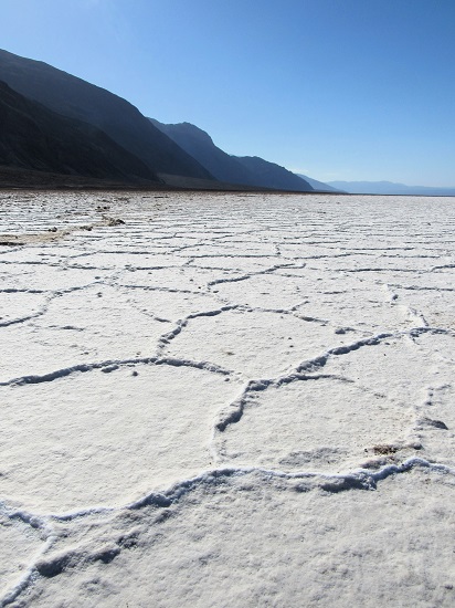
Badwater Basin is the lowest point in the United States, at 282 feet below sea level.  I walked out to the salt flats, and marveled at the fact that the walk was longer than it looked.  Keep that in mind if you walk out there on a hot day.  The salt dries into a honeycomb pattern, and it looks really neat, so I occupied myself with plenty of photos.  I was surprised that there were birds flitting about the saltwater pond.

Artist’s Palette Scenic Drive

The Artist’s Palette scenic drive was pretty, but it hadn’t rained recently when I visited, so the colors weren’t popping the way they do when the ground is wet.  Iron oxide and chlorites give the layers their bright colors.  I got out at the viewpoints and took photos and appreciated the scenery.  It was surprisingly not very busy, but they do say that sunrise and sunset offer the best times to view the colors here.

Zabriskie Point

The Zabriskie Point viewpoint was a bit more crowded with people checking out the surreal layered landscape.  It was named for Christian Zabriskie, one of the prominent men in the Pacific Coast Borax Company.  The largest peak of the landscape here is Manly Beacon, named for one of the gold rush prospectors who came through the area during the California Gold Rush; it rises 823 feet from the canyon floor.  You will probably recognize this view, parts of Star Wars: Return of the Jedi were filmed here.  This is one of the best spots for sunset in the park if you go.

I drove back to the Visitor’s Center as I was passing by and checked out the park movie.  It was interesting, as it showed the perspective of the Native Americans who had traveled and lived here historically.

Harmony Borax Works

Then I headed to see an old borax mining operation – fascinating!  The Harmony Borax Works was started in late 1883, and at its peak employed about 40 mostly Chinese workers.  It was a difficult operation, requiring extracting the sodium borate from the ore.  The ore was dumped into boiling water vats and carbonated soda was added, which made the borax dissolve and the lime and mud settle out.  Then the dissolved borax was moved into cooling vats, where it resolidified and crystallized on rods.  The finished borax was hauled by mule teams on a 165 mile, 10 day trip to Mojave, California.

On the 0.4 mile hike around the borax works, there was an old building where borax was extracted, old mining equipment, and a 20-mule team wagon.  That was so cool to see!  My mom has a Borax 20-mule team wagon model that my parents got before I was born.  It used to sit on my dad’s workbench when I was growing up, and I love looking at it.  It was neat to finally see the place where this model got its start.  I’ll have to get her to dig it out, so it can be displayed once more!

Sand Dunes

The last place I visited that day was the sand dunes.  The signs advertised that sidewinder rattlesnakes live here, but sadly I didn’t see any!  They do burrow underground to escape the hottest temperatures, and are often nocturnal to avoid the daytime heat.  I was fascinated by the fact that this park has so many different ecosystems within its boundaries.

Death Valley was an interesting place.  It doesn’t rank near the top of my favorite National Parks, due to its desolation and heat, but there are still places here that I would like to return to see.  I had to get on my way, and check out Eastern California!

Death Valley National Park History

Death Valley National Park is certainly a unique park, and a beautiful place in its desolation.  It is the largest National Park in the contiguous United States, spanning 3,422,024 acres stretching between four valleys, the Panamint, Eureka, Saline and of course, Death Valley in Southern California.  It also holds the record for the lowest point in North America, and second lowest point in the Western Hemisphere, at 282 feet below sea level in Badwater Basin.  It is the hottest and driest place of all of the U.S. National Parks.  On July 10, 1913, the world’s record for the hottest ambient temperature was set in Death Valley; a temperature of 134 degrees Fahrenheit.

Geographically, Death Valley’s valleys sit between several surrounding mountain ranges, and the fast rate of uplift of the mountain ranges meant that the valley did not have time to erode into a typical V-shaped valley.  Instead, the erosion caused more of a bowl shaped valley, that has steep walls and a more sloping canyon floor.  Geologists apparently call this a wine glass canyon.  I had never heard of a wine glass canyon, but it is an interesting idea!

Death Valley occupies an interface zone between the Mojave and Great Basin deserts along the border of Nevada and California, and it is populated by plants and animals that are adapted to its extreme environment, such as Joshua trees, pinyon junipers, creosote bushes, Bighorn Sheep, and the ever adaptable coyote.  The park is also home to the endemic fish, the Death Valley pupfish, which lives in Salt Creek and Cottonball Marsh (there are two varieties of these pupfish).  They are unique because they can live in water that is 4 times more saline than the ocean, and at temperatures up to 116 degrees Fahrenheit.  They are considered endangered because they are found nowhere else in the world.

Native Americans first began inhabiting the area about 7,000 BC, living in the area during the cooler winter months and migrating to the mountains during the hot summers.  White prospectors on their way to California discovered the area in 1849, when they became trapped.  One of their party died, so the name became Death Valley.  Prospectors did find gold and silver in that is now the boundary of the park, and several small booms occurred from the discoveries.

However, the only ore found in significant amounts was borax, which is used for a number of household and industrial purposes, and gave rise to the imagery of 20-Mule Team Borax, from the mule drawn wagon trains that were used to haul out the product.  Today, remnants of the old borax mines are still visible in the park, with signage explaining the process for extraction.

Death Valley was designated as a National Monument on February 11, 1933, and then upgraded to a National Park on October 31, 1994.  In 2022, 1,128,862 people visited the park.  Visitors can do various activities, including scenic drives, hiking (when it isn’t too hot), and seeing the various views in the park.  There are salt flats and sand dunes, and colorful sedimentary layers.  Not to mention seeing the borax mining equipment that I mentioned earlier. 

There is also a lot of opportunity for those with 4X4 vehicles who can travel on the hundreds of miles of unpaved roads in the park, including hot springs and the Racetrack Playa, where a combination of cold weather, ice and wind make the large rocks move across a dried up lake bed.  That would be fun to see!  There is even a historic home called Scotty’s Castle, but it has unfortunately been closed to the public since the road washed out and the home flooded several years ago.  They have restored the area enough to begin tours of the grounds again, but one day I would like to see the house.

I will tell you about my visit next!


Circus Trip 2018: Valley of Fire State Park

Day 87, Wednesday, October 10, 2018
Valley of Fire State Park, Overton, Nevada

On October 10, 2018, I was in four different states!  I woke up near Zion National Park in Nevada, crossed into Arizona for a hot minute, saw Valley of Fire State Park in Nevada, and then ended my day in California!  What a whirlwind!  I headed out from my campground about 8:30 after packing up my tent and taking a shower.  My destination that day was Valley of Fire State Park in Nevada.  I got there a little after 9 am, thanks to gaining an hour in a time zone change.


Once I arrived, I did the Elephant Rock hike.  It is 1.2 miles through some really cool rock formations, and it was surprisingly empty, I only passed a few other people on the entire hike.  The feature here is obviously Elephant Rock, which I found to be difficult to identify unless you were standing at the perfect angle.  Not all of them can be easy I guess.  Luckily there was a sign! Hint: The first photo below is NOT it!

I drove through parts of the park, checking out the viewpoints along the way.  I saw petrified logs, and a Memorial to a man who died while traveling through the area.  Sergeant John J. Clark was born in 1844 and enlisted in the NY Infantry and served in the U.S. Civil War until he was shot in the hand and contracted typhoid fever.  After he was honorably discharged he moved to Southern California.  In 1915, he was traveling from California to Salt Lake City with a horse and a buckboard wagon, when he apparently got into trouble.  He tied his horse to the back of the wagon, wandered around, then crawled underneath his wagon where he died.  His body was found several days later on June 30, 1915.  It was a reminder to always be prepared for the harsh conditions of the desert.

The cabins were stone buildings built for tourists in the 1930s; there were approximately 9000 tourists annually at that time!  They are neat stone buildings, and there is a beautiful petroglyph panel on the stone face behind the cabins.

Next I went to the Visitor’s Center.  I checked out the exhibits, got some postcards, and planned where I was headed next.  They had a few native snakes and a chuckwalla in their exhibit there; they were neat to see, especially since I didn’t see any while I was out hiking.  Outside, there is a Balanced Rock, so of course I snagged a photo with it.  And guess who I ran into on the way out!?  Carol!  If you remember, I met Carol at Mesa Verde National Park, and spent an evening chatting with her when we both camped at Hovenweep!  Now we met up again purely by accident! 

We decided to go for a hike together, so we drove out the White Dome Road to the Fire Wave trailhead.  The Fire Wave hike was incredible – the colors were amazing!  The hike went out and back to a rock formation with sedimentary layers that looks like of like an ocean wave.  It is only 1.3 miles, so it is a popular hike, but for good reason!  Carol and I enjoyed ourselves chatting and taking pictures of each other.  It was a fun hike!  On the way back we were greeted by a herd of Bighorn Sheep too – I got some good pictures of them. 


When we got back from the hike, Carol and I said our goodbyes for a third time, and went our respective ways.  It is always fun to meet new friends when traveling! 

My time in Valley of Fire was far too short – one day I’ll return and do more of the hikes in the park.  It was a really cool place!  But I was heading to Death Valley National Park in California, so it was time to get on my way!


Circus Trip 2018: Zion Hike

Day 86, Tuesday, October 9, 2018
Zion National Park, Springdale, Utah

After my visit to Cedar Breaks National Monument, I continued on my drive to Zion National Park.  On the way there, I saw a field with bison!  Of course, I pulled over for pictures. 

I have been to Zion once before, so if you want to read those posts, you can find them here: history of the park, Angel’s Landing and other places in the park.

But this time, I was going to spend a bit of time in a different section of the park!  I arrived in the park this time through the east entrance, which is famous for the road that travels through the Zion-Mt. Carmel Tunnel.  More on the tunnel later in the post.

Shortly after I arrived in the park, I saw Bighorn Sheep – and there were even some mamas and babies!  So I had to pull off to get some photos! 

After I got my fill of the Bighorn Sheep, I continued to my first destination; I was going to hike the Canyon Overlook Trail.  This trail is shortly before the Zion-Mt. Carmel Tunnel and it can be very busy, so pack your patience while driving on this road and looking for a parking spot, as it will be slow going (be sure to only park on paved pullouts or you will be cited).  I ended up having to walk a bit to get to the trailhead; just be careful with the traffic!

The Canyon Overlook Trail is only a half mile long (one mile round trip out and back trail), but what it lacks in length it makes up for in stunning views.  The trail has some switchbacks and is uphill on the way to the overlook, with a few sections that take you underneath a rock overhang.  You also get a different view of the Zion-Mt. Carmel tunnel, and see what an amazing engineering marvel it was to tunnel underneath all that rock.  If you have a chance to hike this trail, don’t miss it! 

I relaxed at the top and enjoyed watching the chipmunks skittering about.  It was a warm, sunny day and it was perfect for a hike! 

After my hike, I drove through the tunnel; that was an experience!  The tunnel was started in the late 1920s and finished in 1930 – it is 1.1 miles long!  When I was there, they were only allowing one direction of traffic at a time, and there are significant size restrictions, so you do have to wait in line to get through the tunnel, but it didn’t take too long.  If you have a larger vehicle, be sure to check the park’s website for restrictions and information about buying a permit.  It’s a long, dark tunnel! 

Of course, before I left, I went to the Visitor’s Center and got my parks passport stamped and I got some postcards.  No visit is complete without that!

It was a quick trip, but such a fun afternoon!