Archive | December 2015

Ciao 2015!

Each year, I feel blessed by the life that I’ve been given. I’m healthy, and happy, and have the ability to spend much of my time doing the things I enjoy. I get to spend my days with my husband, friends and family. As I reflect back on 2015, I’m surprised at how quickly it has flown by, and what amazing things I’ve done! 2015 was certainly a year full of travel – so much that I had to expand my Top 10 list to 12!

In no particular order:

  1. We welcomed a new niece to the family in early February, and this little one is busy exploring the world and is just days away from walking!
  2. The El Niño phenomenon brought us a crazy-mild winter. We are talking temps in the 60s in February. Which was perfect for a Valentine’s Day getaway to the first-ever Bubbles Fest at Anne Amie Winery. Eleven Oregon sparkling wine producers, about 25 wines, oysters on the half shell, chocolate, and gorgeous “sitting on the patio” weather! I hope they do this festival again!
  3. Jon and I took a mini-getaway in late March back to Moab, Utah and Salt Lake City. We hiked Arches and Canyonlands National Parks, and we visited Antelope Island in the Great Salt Lake. And, I zip-lined for the first time and loved it!
  4. We knocked another National Park off our list by visiting Mount Rainier in April, on an unseasonably warm weekend. Temps were in the mid-60s! We snow-shoed for the first time, and did several great hikes, in addition to staying at the National Park Inn, our first “in park” accommodations!
  5. We spent a fun long weekend with my family on the Oregon Coast. Jon and I also had a chance to visit a few of the area’s attractions – beer, wine, a lighthouse, and Lewis and Clark’s Winter Fort! The beach at Nehalem Bay State Park is also where I experienced the most beautiful sunset of the year!
  6. There were no major illnesses or injuries among our “herd” this year! Biz is 28, and rocking his mostly toothless smile, after having four more teeth removed in June. Oliver is doing well on his kidney food, and is healthy, other than a random couple of days of vomiting in early December. Oscar still loves getting love on his terms, and Coraline got even pudgier, despite a year on diet food. Time to crack down on portion sizes!
  7. After having such a nice long weekend with Jon’s parents last year, we decided to take a week-long trip to Colorado in August. I planned an epic road trip to see five National Parks and Monuments, and lots of other fun stuff! We had a great time!
  8. I completed my 7th half-marathon in September – the Woodinville Wine Country Half-Marathon. The cool temperature was wonderful, the course was fast, and I shaved 18 seconds off of my previous personal record – despite not having trained for it! Jon got second place in his age division too, and we enjoyed some nice wines and beer at the end!
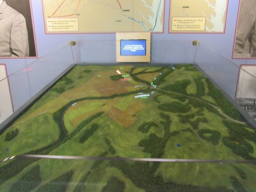
  9. Our big trip this year took place in October – a trip that has been in the works for three years now! We had almost two weeks to tour Virginia (with a couple of stops in other states). We saw Shenandoah National Park, four Presidential homes, five Civil War battlefields and the place where Lee surrendered the Army of Northern Virginia. We also saw several other historic sites, and we finished off with a trip to Chincoteague Island to see the ponies made famous by Marguerite Henry and her children’s books. The memories will last a lifetime.  More posts on the trip are coming!
  10. I’ve been at my new job almost a year, and am enjoying the work (and the vacation accrual!) and making new friends. I miss seeing my old friends every day, but that’s just a reason to make sure we get together.
  11. Jon and I were feeling a bit sun deprived in December with all the rain here in the Northwest, so we booked a last minute weekend getaway to Joshua Tree National Park, in southern California. We hiked to our hearts content and added yet another park to the notches on our belts! The weather was dry the whole time, and it warmed up each day; it was the perfect sunny respite from our torrential downpours!
  12. And last but certainly not least, I celebrated two milestones this year. Jon and I celebrated our fifth wedding anniversary in June, and I turned 40 in September. I’m getting used to the 40 thing…
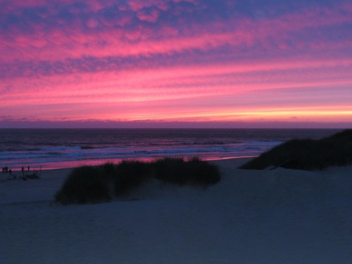
A stunning sunset at the Nehalem Bay Campground.

A Fabulous Sunset!

I know I have a tendency to gripe about the weather (and wouldn’t you if you had moss growing in your ears!), but in reality I know how lucky I am. I hope 2016 brings as much joy as 2015 did. And dear readers, I wish all of you all the best for the New Year!

Virginia 2015: Arlington House

Day 3: Tuesday, October 6, 2015

Have you ever thought about how Arlington National Cemetery, that hallowed ground overlooking Washington, D.C. from the other side of the river, came to be?

Arlington House, the home on the site, was built by George Washington Parke Custis, George Washington’s adopted grandson, beginning in 1802. It was designed by George Hadfield, who had also designed the U.S. Capitol, and it was built in stages in the Greek Revival architectural style. The north wing (1802) and south wing (1804) were built first. Family members at the time would have had to cross outside in order to reach the other half of the house. The center section of the home wasn’t filled in until 1818. The estate was 1,100 acres, with many slaves.

A view of Arlington House in the distance at Arlington National Cemetery.

A view of Arlington House in the distance at Arlington National Cemetery.

Arlington was passed down through the Custis family, and became the home of Robert E. Lee between 1857 and 1861, when he departed to serve in the Civil War – Lee had married into the Custis family. Interestingly, Lee didn’t own it himself; his father-in-law left it to the Lee’s eldest son George Washington Custis Lee when he died in 1857, with stipulations that Lee’s wife, Mary Anna Custis Lee, be permitted to reside there for the remainder of her life.

Before Robert E. Lee took control of Arlington as executor of the estate, the property was not-profitable. His father-in-law had been more committed to leisure pursuits like painting – he was actually a quite accomplished amateur artist – than running a plantation. Lee was able to turn it around without selling off any of the slaves living on the estate; he believed that the sale of slaves would not be in keeping with the wishes of his father-in-law, who stipulated that the slaves there be emancipated within five years of his death. Lee executed that portion of the will, and even taught the slaves to read and write, in violation of the law, because he believed that it would better prepare them for freedom.

By all accounts, Robert E. Lee was a more disciplined master than his father-in-law had been, and the slaves resented it. Several of them attempted (unsuccessfully) to run away. Accounts differ on the severity of the punishment when they were recaptured.

After Lee departed for the war and his family for safer ground further south, the estate was used by Union General Irvin McDowell as his headquarters as he oversaw the troops protecting Washington. The grounds were used as a training ground and encampments for Union soldiers. In 1863, a Freedman’s Village was established there, in order to provide a place where emancipated and escaped slaves could establish themselves.

The North wanted to do more than just use the property. They wanted to punish Lee for his sin of taking up arms against them. So, Quartermaster General Montgomery C. Meigs proposed burying the fallen on the edges of Mrs. Lee’s rose garden – 22 graves in all. They wanted to make sure that Arlington was not a comfortable place to return.  In fact, Lee never did return to Arlington after the war. He was offered an appointment at what is now Washington and Lee University, and he is buried there. In 1874, George Washington Custis Lee sued the federal government for improper seizure of the home, and the Supreme Court agreed; he was awarded Arlington, and then sold it back to the government for $150,000.

Graves around the edge of Mary Lee's rose garden.

Graves around the edge of Mary Lee’s rose garden.

Arlington House was restored beginning in 1925, although in direct violation of the legislation that was passed, it was restored to the earlier time period of George Washington Custis, completely ignoring the contributions or legacy of Robert E. Lee. It wasn’t until 1955 that it was designated as a permanent memorial to Robert E. Lee, and the interpretation changed to the time when Lee lived in the house.

Visitation to Arlington House – the Robert E. Lee Memorial in 2011 was about 576,816; visitors can take a self-guided tour of the first floor of the house. The second floor of the house is currently closed, having suffered earthquake damage in 2011. The Park Service anticipates that the house will be closed for several months in 2016 while the damage is repaired.

I enjoyed our visit, although there were quite a few people roaming around. The home had guides in several of the rooms who pointed out interesting artifacts and answered questions. There were several paintings by Robert E. Lee’s father-in-law and his daughter (Robert E. Lee’s wife). There were several things original to the Lee family, including Robert E. Lee’s red upholstered settee and chairs.

Robert E. and Mary Lee's furniture in the parlor at Arlington House

Robert E. and Mary Lee’s furniture in the parlor at Arlington House


Lee's office, where he wrote the letter resigning his commission in the U.S. Army.

Lee’s office, where he wrote the letter resigning his commission in the U.S. Army.


The cradle were Lee was born - although not in this house.

The cradle where Lee was born – although not in this house.

We toured the garden to see the graves of the Union dead and the Tomb of the Unknown Civil War Soldier (that’s different than the Tomb of the Unknown Soldier).  I checked out the slave quarters, and an interesting display about Selina Gray, one of the slaves who served the Lee family. She helped to safeguard the various George Washington artifacts that had been passed down in the family, by complaining to the Union General stationed at Arlington when soldiers were stealing the valuables.

The Tomb of the Unknown Civil War Soldier - the remains of 2.111 Civil War unknown soldiers are buried here.

The Tomb of the Unknown Civil War Soldier – the remains of 2.111 Civil War unknown soldiers are buried here.

However, it is less known that Selina Gray and several of her children were instrumental in guiding the restoration process of Arlington House, due to her knowledge of the home and furnishings. They assisted with matching paint colors and obtaining period furniture, as well as determining where items should be placed in the home. Despite all this, the Park Service did not have a photograph of Selina Gray until a few years ago, when they were finally able to put a face to this important name in history.

The front of the house was covered in scaffolding during our visit, which didn’t make for great photos, but we were treated to a beautiful clear day so we could easily see the Washington Monument and the Capitol building. No wonder Lee loved it here; it is truly a spectacular view of Washington, D.C.

A view of the Washington Monument and the Capitol from Arlington House

A view of the Washington Monument and the Capitol from Arlington House

While we were at the cemetery, we also saw the tomb of Robert Todd Lincoln, Abraham Lincoln’s oldest son, the only one of his children to live long into adulthood. And no visit would be complete without a visit to John F. Kennedy’s grave. It is poignant in its simplicity – with the eternal flame and the four simple markers – JFK, Jackie, and the two children who died before him.

John F. Kennedy's grave - with the Eternal Flame.

John F. Kennedy’s grave – with the Eternal Flame.

I would have enjoyed wandering around more, but we needed to get to our next destination! George Washington’s Mount Vernon!

Have you been to Arlington National Cemetery? What was your favorite place there? 

A Christmas Riesling Tasting

Christmas was low key this year.  As my parents would be home rather than in Portland, Jon and I decided to spend it with them.  Unfortunately, my mom came down with the flu, and Jon was feeling under the weather as well, so my plans for wiling away the afternoon with games of Scrabble and National Parks Monopoly were thwarted.  Sadly, my dad has since been felled by the flu too, leaving me to wonder if my two week cold was only the preview for a nasty stomach bug.  Fingers crossed…

I had gotten some recommendations at the wine shop for a side by side tasting of Rieslings – Germany vs. Oregon.  Although my mom was unable to partake, we proceeded anyway.  The German Riesling was from the Mosel region – the C.H. Berres 2002 Kinheimer Hubertuslay Kabinett.  The family has been making wine since 1510!  This Riesling was 100% handpicked and aged for 3 months in German oak barrels with wild yeasts.  I’m not really sure what that means, but it sounds fancy.  The wine still held some fruit, but had largely lost the acidity of a younger white – the result was a pleasant semi-sweet Riesling with low alcohol.

C.H. Berres 2002 Kinheimer Hubertuslay Kabinett Riesling

C.H. Berres 2002 Kinheimer Hubertuslay Kabinett Riesling

The Oregon contender was the Lazy River 2011 Private Lumpkin Riesling, a wine that had a nice balance of tart and sweet, with flavors of pear and nectarine.  It reminded me a lot of the many Oregon Pinot Gris (what’s the plural of Gris?).  Even if you haven’t heard of Lazy River, you have likely heard of some of the wineries that they supply Pinot Noir grapes to – Hamacher, Panther Creek, R. Stuart & Co., and Ponzi.

2011 Lazy River Riesling

2011 Lazy River Riesling

Both wines were very good – the German Riesling was a mellow wine with plenty left after 13 years.  The Oregon Riesling was bright and tart and flavorful.  It was hard to pick a winner, but for me and my dad, the Lazy River edged out the C.H. Berres by a nose.  Jon thought the same on Christmas Day, but changed his mind the next day.  Of course, it might have been very different if we were comparing the same year!

How about you – have you done any side by side tastings lately? 


Virginia 2015: Monocacy National Battlefield

Day 2: October 5, 2015

Our last stop of the day after visiting Gettysburg and Harpers Ferry was actually a series of relatively quick stops. We managed to make it to the Monocacy National Battlefield shortly before the Visitor’s Center closed for the day. This is one of the lesser visited battlefields, with annual visitors estimated at about 17,985 – strange, I thought, for being so close to Washington, D.C. 

The Battle at Monocacy occurred on July 9, 1864, when Confederate General Jubal Early tried to cross the Monocracy River at Frederick, Maryland, in order to make an advance on a mostly unguarded Washington, D.C.  He also hoped to divert Union troops away from the Siege of Petersburg. Frederick did not have Union troops stationed there, and Union General Lew Wallace only had about 2,300 mostly unseasoned troops in Washington.

Monocacy National Battlefield

Monocacy National Battlefield

Railroad officials in nearby Harpers Ferry contacted the U.S. Army about Early’s move toward Washington and their concern about protecting the railroad bridge at Monocacy Junction. General Wallace acted without orders to station some troops at the crossing, because he understood what it meant to the defense of Washington should the Confederates get across the river there. After gathering as many troops as he could, the Union had approximately 6,800 troops, compared to estimates of the Confederate forces between 14,000 and 28,000 men.

The Union objective for the battle was to secure the road to Washington. The Union troops fought valiantly, and were able to hold Early’s men for about a day; although at a particularly high cost – 1,294 Union troops were killed, wounded or missing.  The battle and the resulting delay in the Confederate advance meant that the Union was able to get reinforcements to Washington. Early probably could have occupied Washington if he had attacked just a day earlier – the Battle of Monocacy achieved the one day delay needed to protect the capitol. So although the battle was technically a solid Confederate victory, the Union was able to thwart the attack on Washington. 

No Retreat from Destiny: The Battle that Rescued Washington is a 2006 docudrama that discusses the battle. I plan to check it out!

Monocacy National Battlefield is also known for being the spot where Robert E. Lee’s Special Order 191 was found in 1862, wrapped around three cigars.  The orders gave valuable information on Lee’s troops and their movements before the Battle of Antietam.  Unfortunately, most military historians believe that General McClellan did not utilize this information to its full advantage at and after Antietam. 

The Visitor’s Center had a store on the first floor and a nicely done exhibit upstairs, with a digital map and audio about the battle.  I’ve said it before, but I love the maps that show the lines of troop movements during a battle – I find it so much easier to understand what happened!  The upstairs also has a nice deck outside where you can survey parts of the battlefield and the nearby hill where locals tried to hide their livestock from the Confederates. 

The digital battle map at Monocacy

The digital battle map at Monocacy

We drove around to three farms that were pivotal points in the battle. The Best Farm has a farmhouse and several outbuildings.  The stone house at the site is known to have been built in the 18th century, when the farm was owned by plantation owners from Haiti.  They named their Maryland plantation L’Hermitage, and owned over 90 slaves, a large number for Maryland at the time.  They were also known to be quite cruel, as slaveholders go.  By the time of the Civil War, the farm had been sold and was leased to tenant farmers from the Best family.  The main farmhouse on the site is believed to date to the late 1700s as well, with modifications and additions done in the 1860s.   

The side of the Best farmhouse, showing the original home, and the later addition.

The side of the Best farmhouse, showing the original home, and the later addition.

The Stone House at the Best Farm - built late 1700s.

The Stone House at the Best Farm – built late 1700s.

A photo of the Best barn, through another Best barn.

A photo of the Best barn, through another Best barn.

The farmhouse at the Worthington Farm was built about 1851, and I loved the red brick and the wide front porch.  Confederate troops set up positions in the farm’s fields and front yard to assault the Thomas Farm next door.  The Worthington family took shelter in the basement of the home during the battle, and the home was also used as a hospital.  In one of the more amusing anecdotes of the war, the Worthington’s rooster would apparently crow every time one of the Confederate artillery pieces would fire!  While we were wandering around the Worthington Farm, we saw a whole herd of White-tailed deer and a beautiful sunset.

Sunset at the Worthington House

Sunset at the Worthington House


The interior of the Worthington house.

The interior of the Worthington house.


White tailed deer at Monocacy National Battlefield

White tailed deer at Monocacy National Battlefield

Our last Monocacy stop was at the Thomas Farm, whose farmhouse is believed to have been built in 1780.  The Thomas farmhouse suffered extensive damage during the battle from the Confederate artillery on the Worthington Farm – they were trying to dislodge Union sharpshooters.  The Thomas’, like their neighbors the Worthington’s, were hiding in the basement of the home.  It is a miracle that no civilians were killed!  The Thomas Farm now serves as the park headquarters. 

The farmhouse at the Thomas Farm

The farmhouse at the Thomas Farm


The barn at the Thomas Farm. Why would they put outhouses here to ruin my pretty picture!

The barn at the Thomas Farm. Why would they put outhouses here to ruin my pretty picture!

The structures at all three farms are in various states of preservation, but it was nice to see them protected for future generations.  The entire battlefield hasn’t had such a happy ending though, as I-270 was routed right through a portion of the battlefield.

Once the sun went down, we went off in search of dinner. We ended up at the Brewer’s Alley in downtown Frederick, where the blackened catfish dinner caught both of our eyes. I had mine with the Caesar salad and a Hefeweizen; after dinner I tried a 5 oz. Oatmeal Stout.  Jon had his catfish with a regular salad, and their Riot Rye Pale Ale.  He finished his meal off with a 5 oz. beer too – their Oakily Dokily Neighbor.  We did something rare for us that night too – dessert!  The Peach Cobbler with homemade peach ice cream sounded delicious, and it was!  It was a great meal! I would have loved to see more of downtown Frederick, but it was time to call it a day – we had done a lot! 

Driving distance for Day 2:  123 miles – Frederick, MD – Gettysburg National Military Park – Harpers Ferry National Historical Park – Monocacy National Battlefield – Frederick

Hotel for the night: Back to the Sleep Inn in Frederick Maryland for one more night.

My Christmas Spirit

My cold is still hanging on, almost two weeks later, but I’m feeling better day by day!  This morning I got my exercise in the form of a 3 mile walk to work, because my car battery pooped out while Christmas shopping last night.  After my parents drove over and gave me a jump (Thanks!), I dropped the car off at the shop to get its usual service and its new battery.  Thankfully, that’s all that was wrong.  And thankfully, it wasn’t raining this morning during my walk!

After getting home tonight (after striking out again on a book that I’ve been looking everywhere for), Jon surprised me with a gift.  He emphatically stated that it was “not a Christmas gift.”  But it looks pretty Christmas-y to me!

Our new lighted owl decoration. Isn't he cute!?

Our new lighted owl decoration. Isn’t he cute!?

How are all of you doing?  If you celebrate Christmas, are you ready for it!?


Coraline under the Christmas tree.

Coraline under the Christmas tree.

Virginia 2015: Harpers Ferry NHP

Day 2, October 5, 2015

Rarely do you get the opportunity to travel in 3 states before 1 o’clock in the afternoon! We left Gettysburg, Pennsylvania shortly after noon, and made our way to Harpers Ferry, West Virginia, crossing back through Maryland along the way.

The Harpers Ferry National Historical Park was established on June 30, 1944, and there are approximately 255,348 visitors that visit the park each year.  We stopped at the Visitor’s Center to get my stamps, then rushed outside to catch the bus down to the site. Harpers Ferry operates a shuttle service because parking is limited at the site. We probably didn’t need it on a Monday in early fall – it really wasn’t that busy.

Harpers Ferry National Historical Park preserves the historic town of Harpers Ferry, the site of the federal armory, and of course, the site of John Brown’s Raid. Harpers Ferry was settled in the 1700s, and Robert Harper obtained a land patent in 1751 and established a ferry to cross the river.  George Washington began construction on the federal armory there. It was an ideal location with plenty of river water for facilitating the manufacturing process. Interestingly, a large part of the weapons and hardware for the Lewis and Clark expedition were manufactured here.

Harpers-Ferry-Hotel

The Stephenson’s Hotel in Harpers Ferry

Harpers Ferry is the site of the infamous John Brown’s Raid. In 1859, abolitionist John Brown tried to organize a slave revolt to take over the federal armory in Harpers Ferry. While a few blacks left their homes and joined the raid, John Brown did not get the large numbers of slaves that he wanted or expected to join his cause.

John-Browns-Fort

John Browns Fort

John Brown managed to hole himself up in what is now called John Brown’s Fort, originally a firehouse. He and his supporters waited, trapped by a hastily formed militia from the town of Harpers Ferry. A young Captain Robert E. Lee was the U.S. Army Officer charged with putting down the revolt. He arrived with his men, assessed the situation, and gave Brown a chance to surrender. When that didn’t happen, Lee’s men stormed the fort and put down the revolt. In less than three minutes…

We checked out the firehouse where John Brown sought refuge; it was fascinating to see after reading so much about John Brown’s Raid – it was much smaller than I imagined. It has been moved several times; the current site is actually its fourth location. I was able to see the original location of the Fort, and where Robert E. Lee mounted his offensive; we also saw the current location (they didn’t mark the interim locations). We also checked out the site of the armory that John Brown was trying to capture.  It is gone now, destroyed by fire later I believe, but they have the buildings outlined on the ground.

Pillar-John-Browns-Fort

The monument marking the original location of John Brown’s Fort – with the current location in the distance.

Harpers Ferry continued its historical significance during the Civil War; it changed hands at least eight times. When Virginia seceded in 1861 (West Virginia hadn’t broken off yet), U.S. troops tried to burn the arsenal to prevent it from falling into Confederate hands; however, the townspeople saved the equipment from the buildings and it was moved closer to Richmond.

Jon and I wandered around the town and checked out the various buildings.  Jon and I both enjoyed seeing the impressive confluence of the Potomac and Shenandoah Rivers. They are both huge rivers, and it was neat to see where they come together.  Unfortunately for Harpers Ferry, these two powerful rivers flood – one of the buildings in the lower town has a marker showing the high water mark of several of the floods that have inundated the town.

Confluence-Potomac-Shenandoah

The greener waters of the Potomac blend with the muddier waters of the Shenandoah to form an even mightier Potomac.

Harpers-Ferry-Flood-Marks

The flood marker is on the left side of this building. Those are some impressive floods!

Adjacent to Harpers Ferry is the Chesapeake and Ohio (C&O) Canal Towpath, which follows the historic towpath where horses and oxen towed barges on the river. You can access it by taking a short footbridge across the Potomac River; we walked across the bridge and stood directly above the mighty Potomac.  The footbridge and the hiking trail at this point is part of the Appalachian Trail, the 2000 plus mile hiking trail that travels from Georgia to Maine.  It is considered to be the psychological midpoint of the trail; even though it doesn’t really mark the middle.

Me-Harpers-Ferry

Me on the bridge at Harpers Ferry

Instead of taking the shuttle bus back to the Visitor’s Center, we decided to walk; the path takes you along the river, along the historic canal, and also onto Virginius Island, in the Shenandoah River. There, we saw the ruins of several structures; one interesting building was a pulp mill.  And I absolutely loved what we found in the water along the way – turtles! Painted turtles were sunning themselves all over logs and rocks poking up through the canal. We also saw one turtle that was much bigger than the rest; I’m pretty sure he was a snapping turtle. He was covered in algae, and kind of looked like an alligator the way he was mostly hidden under the water.

Harpers-Ferry-Pulp-Mill

The remains of the Shenandoah Pulp Factory – built 1887-1888 – closed 1935 – destroyed by flood 1936.


The hike was quite enjoyable, with the last section being an uphill climb on stairs and a trail in the woods. I loved being able to compare the forest there with the forest at home – we have much more undergrowth in Northwest forests. It was a good chance to get some exercise and see a bit of scenery too!  Harpers Ferry was a wonderful place to visit!

My Annual Pacific Northwest Winter Gripefest

Dearest Readers,

By the reports on the news, you might be wondering if the entire Pacific Northwest has flooded into the ocean. We haven’t, but pretty close. It has been raining for weeks. Straight. With. Almost. No. Break. (Except yesterday). We are always rainy this time of year, but we are currently above the already wet average for the month of December. It’s downright soggy.

I’m tired of the rain. Plus I’m tired of going to work in the dark, and coming home in the dark, and I’m looking forward to the winter solstice which will at least mean the beginning of lengthening days. We probably won’t get drier days for a while though!

 I heard about you East Coasters who were getting unseasonably warm temps last week – I was so jealous! Yes, I’m sorry about your ski areas and all, but wandering around in shorts sounds so good right now! Who cares about snow sports when you can have wine on the patio!  But if you really want great skiing, come on out – they anticipate that our ski area will have reached the average snowfall for the entire year by this weekend. 

So while you might be dreaming of a white Christmas, I would settle for a dry Christmas. One in which the rain stops, even for just a little while.  A peek of the sun between the clouds would be a bonus.  And yes, I realize I’m just cranky, and I should get into the holiday spirit, and I will try to do so, just as soon as I kick this cold I have been fighting for the last week.  In the meantime, can I please have another glass of wine?  

Sincerely,
The Grinch.  🙂

Virginia 2015: The Soldier’s National Cemetery

Day 2, October 5, 2015

It is called the Soldier’s National Cemetery – officially.  But like me, perhaps you have always thought of it as Gettysburg National Cemetery.  We took the time to visit when we visited Gettysburg. The cemetery already existed as the town cemetery at the time of the Civil War, but after the battle work began to designate one cemetery for the Union dead. Immediately after the battle, the dead had been hastily interred at several nearby sites, including churchyards, on the grounds outside hospitals, and on the fields of the battlefield itself. Some corpses were not found until much later, and had begun to decompose without being buried.

As land was acquired adjacent to the town cemetery, the remains were reinterred. They first had wooden markers, but then flat stone markers were laid in 1865. The Civilian Conservation Corps set the gravestones in concrete in 1934. The Civil War graves are set in concentric semi-circles radiating out from The Soldier’s National Monument, begun in 1865 and dedicated in 1869.  Today, the remains of 6,000 servicemen are buried here, including about 3,500 Civil War soldiers.  Over half of the Civil War burials belong to unidentified soldiers.  Later burials include servicemen extending up through the Vietnam War in 1972, in a later acquired annex of land.


Gettysburg National Cemetery. The flat markers in the foreground are the Civil War graves.

Gettysburg National Cemetery. The flat markers in the foreground are the Civil War graves.


A view of the Soldier's Monument, with Civil War graves in the foreground.

A view of the Soldier’s Monument, with Civil War graves in the foreground.

Of course, the cemetery is also famous for the speech that was given here. Lincoln’s Gettysburg address is one of the most recognizable speeches in U.S. history, although Lincoln didn’t think at the time that it would be long remembered. He even said so in his remarks.  In fact, his speech here was mostly an afterthought. Edward Everett, Massachusetts statesman and orator, had been chosen to give the dedication at Gettysburg. The cemetery committee asked the President at the last minute to give “a few appropriate remarks,” after Everett finished speaking. Here’s what Lincoln came up with:

“Four score and seven years ago our fathers brought forth on this continent a new nation, conceived in liberty, and dedicated to the proposition that all men are created equal.

Now we are engaged in a great civil war, testing whether that nation, or any nation so conceived and so dedicated, can long endure. We are met on a great battlefield of that war. We have come to dedicate a portion of that field, as a final resting place for those who here gave their lives that that nation might live. It is altogether fitting and proper that we should do this.

But, in a larger sense, we can not dedicate, we can not consecrate, we can not hallow this ground. The brave men, living and dead, who struggled here, have consecrated it, far above our poor power to add or detract. The world will little note, nor long remember what we say here, but it can never forget what they did here. It is for us the living, rather, to be dedicated here to the unfinished work which they who fought here have thus far so nobly advanced. It is rather for us to be here dedicated to the great task remaining before us—that from these honored dead we take increased devotion to that cause for which they gave the last full measure of devotion—that we here highly resolve that these dead shall not have died in vain—that this nation, under God, shall have a new birth of freedom—and that government of the people, by the people, for the people, shall not perish from the earth.”

Lincoln only spoke for about two minutes – far less than the two hours that Everett spoke. In fact, there are no photographs of Lincoln speaking – historians believe it is because the photographers capturing the event were surprised by the brevity of his remarks. But the speech brings tears to my eyes every time I hear or read it, and I can’t imagine I’m the only one so affected.

Another view of the Soldier's Monument

The New York State Monument at the Soldier’s National Cemetery

For a long time, Lincoln was believed to have given his speech near the Soldier’s Monument, but more recent historians studying photographs place the dais within the existing town cemetery, Evergreen Cemetery. The ranger was kind enough to point out where to stand and look through the fence to get a rough idea of where Lincoln stood.  If we hadn’t spoken to the ranger, we wouldn’t have known, as the signage at the cemetery still gives the old location.

To the right of the cannon, there is a small tree. Behind that is a mausoleum believed to be near the site where the dais was placed for the cemetery dedication.

To the right of the cannon, there is a small tree. Behind that is a mausoleum believed to be near the site where the dais was placed for the cemetery dedication.

The cemetery is beautiful – with historic wrought iron fences and brick work, and pathways. The various trees are marked with their species names, and the squirrels and birds clearly enjoy it.  We wandered among the graves and the trees for a little while, reflecting on the incredible sacrifice of these men, and the importance of this place.

Some of the World War I graves at Gettysburg

Some of the World War I graves at Gettysburg


Virginia 2015: Gettysburg NMP

Day 2, October 5, 2015

Gettysburg today is a beautiful, quiet town in the Pennsylvania countryside.  But that peace was shattered for three days in July, 1863, when the Battle of Gettysburg resulted in the Civil War’s most costly battle in terms of human life.  Over 46,000 men were killed, wounded or missing in the three days of battle, and it forever changed this small, farming community.

Gettysburg National Military Park

Gettysburg National Military Park

After I had worked out our trip schedule for our Virginia trip, Jon decided he wanted to fit in a quick trip to Gettysburg, Pennsylvania.  And before you tell me that the title of this blog says Virginia, but I’m roaming around in Pennsylvania, there’s a reason!  I decided to keep a consistent heading name for all my posts for this trip – even though we did a couple of detours outside of Virginia!  Gettysburg was only about 40 minutes away from where we were staying in Frederick, Maryland after all! If it were up to me, Gettysburg would never be a quick trip, but I had done the full battlefield tour (with audio tour) before, so I made my peace with doing Gettysburg on a smaller scale this time. Jon is just never going to be an audio tour kind of guy, and I have to accept that…

We got to Gettysburg around 9:30-10 am and did a quick stop at the Visitor’s Center for stamps and postcards. We decided not to see the museum and the movie (that part pained me…), so we could spend more time on the battlefield.  I still need to get back there and do that!

One of the hundreds of cannon that sit on the battlefield.

One of the hundreds of cannon that sit on the battlefield.


Another of the many statues featuring horses at Gettysburg.

Another of the many statues featuring horses at Gettysburg.

Jon wanted to see where Pickett’s Charge occurred, so we started there. We checked out the Angle and the High Water Mark, where the Union Army repulsed the Confederates on the last day of the battle. I was again amazed by the sheer insanity determination that must have been involved in sending those soldiers across a mile and a half of open field. Pickett’s troops, and the other divisions that participated in the charge, were decimated.  Standing there, it is easy to see why.

The Codori Farm was in the middle of Pickett's Charge on the third day of the battle in 1863. This barn is a replacement; the original was torn down in 1882. The farmhouse sustained damage from shelling during the battle.

The Codori Farm was in the middle of Pickett’s Charge on the third day of the battle in 1863. This barn is a replacement; the original was torn down in 1882. The farmhouse sustained damage from shelling during the battle.

Half of Pickett’s division was left dead or wounded on the field. The casualty rate for the men that reached the Angle was over 70 percent. When Pickett’s remaining troops made their way back to Seminary Ridge, Lee asked Pickett to organize his troops in the rear to prepare for a counter attack by the Union. Pickett reportedly replied, “General Lee, I have no division now.” Truer words were never spoken.

The Pennsylvania Monument is the largest monument on the battlefield; it also has interior stairs that lead you to the top of the monument for a bird’s eye view of many of the features of the battlefield.  I climbed to the top and surveyed the view; you can see a lot from up there!

The view from the top of the Pennsylvania Monument.

The view from the top of the Pennsylvania Monument.


A plaque marking directions and distances from the top of the Pennsylvania Monument

A plaque marking directions and distances from the top of the Pennsylvania Monument.


We also checked out Seminary Ridge, where General Lee staged the Confederate line. I do love the gigantic statue of Lee that has been placed as a monument on Seminary Ridge. He’s on a horse, so of course you know I love it!  I’m sure there are lots of people who would argue that it should be removed along with all the other Confederate statues, but I think there is a valid historical reason to leave them, and learn from the past. If we hide all traces of our past, how will people come to understand the complicated road we have traveled? But I digress…

A statue of Robert E. Lee on the battlefield.

A statue of Robert E. Lee on the battlefield.


Our last stop on the Gettysburg Battlefield that day was at Little Round Top, where Joshua Chamberlain, after defending the hill valiantly and running out of ammunition, ordered a fixed bayonet charge to repulse the Confederates charging up the hill from Devil’s Den. Before the Union Army defeated the charge, men were fighting hand to hand on the hill.

Looking down at Devil's Den from Little Round Top

Looking down at Devil’s Den from Little Round Top.


The rock strewn hillside and Devil’s Den’s, a bowl shaped collection of rocks at the base of Little Round Top, are much the way they were during the battle. You can still see where union troops created defensive walls using the existing large boulders, and the numerous smaller rocks on the hill. Chamberlain was the recipient of the Medal of Honor for his bravery on Little Round Top, 30 years after the war.

I found a toad on Little Road Top! He is an Eastern American Toad.

I found a toad on Little Road Top! He is an Eastern American Toad.


We also made one additional stop in Gettysburg – The Gettysburg National Cemetery.  I will post about it next!

Gettysburg NMP History

Almost everyone (I hope) knows the name Gettysburg and what happened here.  It was a monumental battle between the United States Army and the Confederate Army during the American Civil War.  A three day battle which would end with the most casualties of any one battle in the Civil War.  Over 46,000 men were killed, wounded or missing at the conclusion of those three days.  It was a battle that pitted soldiers against each other in hand to hand combat, in impossible charges over open fields, and in insufferable weather conditions.  It was a battle that would change the tide of the war, even though it would rage on for almost two more years.

Gettysburg National Military Park today includes most of the battlefield, and many of the other areas that were important to the battle, such as staging and supply areas and hospitals.  It also includes the cemetery, which is quite possibly the most famous cemetery in the United States, due to a small speech given here by Abraham Lincoln when dedicating the cemetery several months after the battle.  Lincoln’s speech was over in less than 2 minutes, but it has lived on in the collective hearts of the nation.  I learned it in school, and I bet you probably did too.

Gettysburg National Military Park

Gettysburg National Military Park

The first land was protected in 1863, and gradually more land has been added over the last century and a half.  Gettysburg was designated as a National Military Park in 1895, and eventually placed under the administration of the National Park Service.  To date, 3,965 acres have been protected, with new land added to the park as recently as 2009.  Gettysburg also protects over 1,320 monuments, 410 cannons, 148 historic buildings, 3 observation towers, and 41 miles of avenues, roads, and lanes.  And although it is not known whether any remains have yet to be discovered on the battlefield, soldiers who fought at Gettysburg were found where they fell as recently as 1996; there are probably more men still resting there.  It is truly sacred ground.

The Visitor’s Center protects the Cyclorama, a late 19th century room sized oil painting on canvas, that when viewed from a platform immerses the viewer in the scene.  It is fascinating to see in person.  Sadly, the park sold their Electric Map, a 30′ by 30′ display in relief of the battlefield with dozens of light bulbs that light up to show the troop movements on the battlefield.  I saw it when I visited Gettysburg in 2008, and gained an understanding of the movement of the battle over those three days that is hard to appreciate from watching a movie.  It may have been “old” technology, but it was effective.  If you want to see a video of the Electric Map – there’s one at this website.

in 2010, 1,031,554 people visited the park, making it one of the more visited units within the Park System.  Although I visited in 2008, I was looking forward to spending more time there, and we were going to see it on our trip!