Archives

Filters

A long, hard week (and it is only half over!) called for a long walk with a girlfriend tonight, a late dinner, and no time to catch up on this blog.

Just a little playing with filters before I tumble into bed.

A cannon at Gettysburg, coupled with dreams of vacation.

Virginia 2015: Fort McHenry

Day 13: Friday, October 16, 2015

We all know the Star Spangled Banner, and if you are anything like me, you have sung it (badly) a million times, but have you ever thought about the song and what it represents?

The last stop on my whirlwind Virginia tour, before I flew home from the Baltimore airport was a brief stop at Fort McHenry, in Baltimore’s Inner Harbor.

Fort McHenry

Fort McHenry

I headed out in the mid-morning from Chincoteague Island, and had about a three hour drive to reach Baltimore. I had a quick lunch, and that left me with just about an hour to visit the fort before I needed to head to the airport for the 5 pm flight.

Fort McHenry was built in 1798, the second fort at the site to defend Baltimore Harbor. It is a five point star shaped fort, an effective defense because any two points of the star can create a crossfire for attackers arriving by sea. It also has a dry moat to prevent attack by land. It is named after James McHenry, a physician who served as an aide to Washington during the Revolutionary War. He also was one of several foreign-born signers of the Constitution, while a member of the Continental Congress. He served as the Secretary of War for both the Washington and John Adams administrations.

The outside of the fort.

The outside of the fort.

During the War of 1812, on September 13, 1814 at 6:00 am, British warships began a 25 hour bombardment of the fort. Due to the defense provided by 22 ships the Americans had sunk in the harbor, the British could not continue further up the river, and very little damage was done on either side of the battle. Three soldiers and one civilian woman were killed in the fort; she was carrying supplies to the troops when she was cut in half by a bomb – 24 Americans were wounded. One British ship sustained light damage from cannon fire, and only one man was wounded.

The Entrance at Fort McHenry

The Entrance at Fort McHenry

The British gave up when they saw that their bombardment wasn’t having its desired effect – and they had that pesky problem of running out of ammunition… And here’s where the Star Spangled Banner comes in… Francis Scott Key, the author of the Star Spangled Banner, had been sitting on a ship behind the British line; he had been speaking with the British commanders before the bombardment began in order to get a prisoner exchange going. After they wrapped up their conversation, the British made Key and his colleague stay behind the British line until the battle ended.

When the smoke cleared the next day, Key looked up to see if the flag was still there, and was so moved to see it that he wrote a poem that he named Defence of Fort M’Henry. It was later set to music and became known as the Star Spangled Banner. Interestingly, although it was a popular patriotic song, it didn’t become our national anthem for another hundred plus years, in 1931.

The Powder Magazine and Fort Building.

The Powder Magazine and Fort Building.

After the Battle of Baltimore, Fort McHenry remained an active fort through World War II – used as a prison during the Civil War, and by the Army as a hospital for troops returning from the front in World War I. It transitioned to a Coast Guard Fort in World War II.

It became a National Park in 1925, but in 1939 was re-designated as a National Monument and Historic Shrine – it is the only site within the system to carry this double designation.

It is also the place where all newly designed American flags are flown first – the first 49 and 50 star flags are still located at the site.

The fort is preserved to look as it did during the War of 1812, and while I didn’t have a lot of time, I was able to explore the fort. It is hard to see the star shape from the ground, but it is very apparent in aerial photos. I was able to check out the living quarters, various store rooms, and the powder magazine, which had sustained a direct hit by a bomb during the battle – either it was a dud or the rain extinguished the fuse!

The Powder Magazine at Fort McHenry

The Powder Magazine at Fort McHenry

I also went up to the walls of the fort, to look out over the harbor. It is a little tough to imagine what the view would have been like over 200 years ago, as there is all sorts of industry and tall buildings on the other side of the harbor now.

The view from the top of Fort McHenry

The view from the top of Fort McHenry

I certainly enjoyed seeing such an integral part of our nation’s history!

But too soon, it was time to make our way back to the airport, return the car, and fly home. I had such a great time seeing so many historic sites on the trip, but it was nice to come home…

Driving Distance for Day 13: 181 miles – Chincoteague Island, VA – Fort McHenry – Baltimore Airport

Entrance Fee:  $10 per person or free if you have a National Parks Pass.

For the night: My own bed!

Virginia 2015: Chincoteague NWR

Day 12: Thursday, October 15, 2015

After our boat tour and lunch, we made our way over to Assateague Island, to check out Chincoteague National Wildlife Refuge. Yes, it’s confusing that Chincoteague NWR is on Assateague Island – I don’t know why either…

Chincoteague National Wildlife Refuge

Chincoteague National Wildlife Refuge

I talked in my last post about the history of how the ponies got to the island, but Assateague Island and the refuge contain much more than ponies. In the 1800s, there was a small community on the island, clustered around the lighthouse.

The original lighthouse was built in 1833, to warn ships of the dangerous shoals offshore. Construction began in 1860 on a newer, taller lighthouse, but it was delayed by the outbreak of the Civil War. Construction was completed in 1867. It has a First Order Fresnel lens, the largest type of lens made.

The lighthouse is currently undergoing restoration work – it was repainted, and the gallery deck was repaired so visitors can climb to the top of the light. I was there in the off season, so it wasn’t open, but I can imagine how cool it would be to climb to the top and see the view!

A close-up of the Assateague Lighthouse

A close-up of the Assateague Lighthouse

The community that lived on the island began to move away after one man bought a large tract of land and began restricting overland access to Tom’s Cove. The villagers gradually barged their homes and buildings over to Chincoteague Island to continue there. In 1943, most of the Virginia side of the island was sold to the U.S. Government for the purpose of creating a National Wildlife Refuge.

The refuge has several trails; some of them take you by the fenced area where the ponies are, so of course, that’s where I wanted to start. The path is level and paved, so it is more a walk than a hike. But, I found myself having to walk quickly to try to avoid all the mosquitoes! I wasn’t expecting them to still be so ravenous in the middle of October!

I think this was a Boat Tailed Grackle?

I think this was a Boat Tailed Grackle?

I was able to get some good photos of the ponies from the viewing station though, so I was willing to put up with some mosquito inconvenience. They looked so peaceful, just grazing on the grass and enjoying the sunshine.

Ponies!

Ponies!


This little pinto was so cute!

This little pinto was so cute!

I also took a detour from the trail out to the beach, where I found a lot of horseshoe crab shells. They look so prehistoric! Unfortunately, there were mosquitoes on the beach too, although not as many. Bothersome critters!

A unique driftwood "sculpture" with horseshoe shells.

A unique driftwood “sculpture” with horseshoe shells.

My last walk for the today was to see the lighthouse – this path is about ½ mile roundtrip. It was great to get a close up view of the lighthouse with its red and white candy striped exterior. It is a very tall structure!

After that, I called it quits in the woods, and went over to the beach. It was a gorgeous, sandy beach – I can understand why this area is such a vacation destination in the summer. I walked along for a little while, just taking it all in, watching the herons and egrets fish for their dinner in the nearby marshes, and listening to the birds.

A Great Egret at Chincoteague

A Great Egret at Chincoteague

A Snowy Egret at the refuge.

A Snowy Egret at the refuge.


Another Great Egret fishing.

Another Great Egret fishing.


Geese hanging out on the refuge.

Geese hanging out on the refuge.

And before we left, I was treated to a fantastic view of a mare and her foal – they were so peaceful.

A mama and her foal.

A mama and her foal.

Dinner that evening was a quick stop for a sandwich at Subway, followed by a front row view of a beautiful sunset. The end of a great day…

The sunset started out a brilliant orange...

The sunset started out a brilliant orange…


The sunset turned a gorgeous pink later on...

The sunset turned a gorgeous pink later on…

Driving Distance for Day 12: only a few miles – Chincoteague Island, VA

Entrance Fee:  $8 or free if you have a National Parks Pass.

Hotel for the night: The Fairfield Inn on Chincoteague Island again – excellent!

Virginia 2015: Chincoteague and A Pony Tour

Day 11: Wednesday, October 14, 2015

The last destination of our Virginia trip was Chincoteague Island. I had grown up reading the Misty of Chincoteague stories, had my collection of Breyer horse Misty and her foals, and wanted to see where the real life Misty had come from.

If you aren’t familiar with Misty, she was a real live Chincoteague pony who has purchased by children’s author Marguerite Henry. Misty and her family were the subject of several of Henry’s books, detailing her fictional life on Chincoteague Island with a young boy and girl and their family in the 1940s. For this girl who grew up horse-crazy, to see the island where Misty came it was the stuff of dreams come true. And now, we were there and I was going to see ponies!

The town park has a cute statue of baby Misty and her feathered friends.

The town park has a cute statue of baby Misty and her feathered friends.

The ponies live on Assateague Island, which is one of the barrier islands off mainland Virginia. It is uninhabited, with the people living on nearby Chincoteague Island. There are a couple different explanations about how the ponies got there, but each story has some supporting evidence and which one is true is unknown.

A palomino stallion on Assateague Island.

A palomino stallion on Assateague Island.

  1. The inhabitants of Chincoteague Island and the mainland placed their horses out on Assateague Island in order to get out of paying taxes on them. Over the years, some went wild, or were forgotten, and there they remain.
  2. In the 17th century, a Spanish galleon wrecked off the coast of Virginia, and some of its cargo of horses were able to swim to Assateague Island, where they remain.

The Chincoteague ponies are actually horses, but a couple hundred years of living on a salt marsh island, subsisting on poor quality forage, as well as years of inbreeding has created animals with a smaller stature and more pony-like characteristics. The pot bellies that are evident on many of the ponies are also a trait that has developed due to their poor quality diet.

A pinto mare on Assateague Island.

A pinto mare on Assateague Island.

There are two herds of ponies, separated by a fence that divides the Virginia side of Assateague Island from the Maryland side. The Virginia side is Chincoteague National Wildlife Refuge, and although they allow the ponies to live there, the refuge management has enforced a limit on their numbers.

Every year in July, there is an pony penning on the Virginia side of the island, where the ponies are technically “owned” by the Chincoteague Island Volunteer Fire Department. The ponies are swum across the short distance between the islands (it is a really short distance, and very small foals are given a lift), given veterinary care, and some of the foals are auctioned off, both to earn money for the Fire Department and to control the population. The official annual event began in 1924, and features the usual festival accoutrements, lots of food, a carnival, and fireworks.

American Oystercatchers on Assateague Island with a background of ponies!

American Oystercatchers on Assateague Island with a background of ponies!

On the Maryland side of Assateague Island, the second herd of ponies are considered wildlife by the National Park Service. Other than contraceptive darts, these ponies are given no medical care, and live their lives as truly wild animals.  Aside from all the tourists that undoubtedly feed them tons of junk food – you can get a fine for it, but that never seems to stop dumb people.

And now I was finally there, and even though it wasn’t during the annual festival, I was going to get to see the ponies. I booked a tour on a “pony boat,” my term for the small boat that was scheduled to take us around the island to see the ponies from the water. And in the afternoon, we were going to visit the Wildlife Refuge on Assateague Island to see them from a different view.

A bald eagle soaring above Assateague Island.

A bald eagle soaring above Assateague Island.

That morning I woke up early and took a stroll around Chincoteague Island to see what there was to see. It was pretty quiet on a Thursday in October. It was nice to see the pink light of the sunrise reflecting off the water, even if the sunrise itself was blocked by houses.

Seagulls enjoying the sunrise on Chincoteague Island

Seagulls enjoying the sunrise on Chincoteague Island


They had those giant chairs! Of course there was no one around to take my picture sitting in one...

They had those giant chairs! Of course there was no one around to take my picture sitting in one…

We met Captain Dan at the dock to commence our “pony boat” excursion. There were two other couples on the boat with us, so it certainly wasn’t crowded at all. And off we went. Captain Dan grew up on the island, and shared lots of interesting information about the history of the island, the patterns of erosion of the sandbars, the nearby military facilities, and the wildlife. And of course, the ponies.

Captain Dan had a book with photos of all the ponies that live on the island, complete with their birth dates and parentage (if known). He knew which stallions had bands consisting of which mares, and where each group liked to hang out. He told stories of various ponies and their lives.

Two pinto mares on Assateague Island.

Two pinto mares on Assateague Island.

While I wouldn’t say it was a banner day for pony spotting, we saw about 8-10 ponies over the course of our three hours on the boat. We had plenty of time to observe the ones that we saw. We also got great views of the lighthouse on the island, two bald eagles, and a tri-colored heron! The weather and the scenery were fantastic and it was wonderful to be able to relax for a couple of hours out on the water.

The Assateague Lighthouse - built in 1867.

The Assateague Lighthouse – built in 1867.


A Tri-Colored Heron - he was gorgeous!

A Tri-Colored Heron – he was gorgeous!

If you are visiting, I would highly recommend Captain Dan’s tour – I loved it!  We finished off our morning tour with lunch at the Jackspot restaurant again; I couldn’t get enough of those oysters that we had the day before. And at $1 per oyster, who could go wrong!

My fish tacos at Jackspot

My fish tacos at Jackspot

Virginia 2015: Yorktown

Day 11: Wednesday, October 14, 2015

Near Jamestowne is another site that is part of the Colonial National Historical Park, best known for being where the United States won her independence.  Yorktown was where the Revolutionary War ended!

Yorktown was a prosperous trading port during the 17th century; it shipped tobacco and other trade goods back to England.  Incoming freight included household goods, wine and liquor, firearms, and slaves.  The town has a lower section near the water, where warehouses and shops were built, and an upper portion at the top of the bluff where residents established fine homes.

A sailing ship at Yorktown

A sailing ship at Yorktown

It continued to prosper until 1781, when George Washington and Comte de Rochambeau with a combination of American and French troops, chose Yorktown as the site of their now famous siege of the British troops, led by General Charles Cornwallis.  Washington planned diversionary tactics to make it look like the Americans were planning their siege on New York, and then moved troops down to Virginia to get ready for the siege at Yorktown.  Meanwhile, Washington coordinated with Comte de Grasse of the French Army to provide a naval blockade of the Chesapeake Bay, to block Cornwallis’ escape.

A trench and cannon at Yorktown

A trench and cannon at Yorktown

The American and French troops began to surround Yorktown on September 28, 1781.  While they were establishing their positions, the British kept up a strong bombardment of the positions, trying to prevent the Americans from becoming entrenched.  The siege began on October 14, 1781, and the American and French troops built a series of trenches from which to bombard Yorktown, progressively moving their lines closer to the town.  The siege didn’t last long – on October 19, 1781, Cornwallis could see that he was out of options and surrendered to Washington.

Casualties numbered 88 killed and 301 wounded for the American and French forces; the British had 156 killed, 326 wounded and 70 missing.  Ultimately, Cornwallis surrendered 7,087 troops in Yorktown and another 804 British sailors.

Interestingly, the American government authorized a monument to be built commemorating the siege at Yorktown right after it ended, but the money to pay for the monument wasn’t appropriated for another 100 years.  This sounds familiar!

The monument at Yorktown - erected 1881.

The monument at Yorktown – erected 1881.


A pretty bird at Yorktown - I have no idea what kind.

A pretty bird at Yorktown – I have no idea what kind.

We wandered around the site and checked out the historic homes that remain from the period; there are some original homes and some that have been reconstructed.  There are typically signs outside that mark which are which.  We were able to tour the Nelson house, which was built around 1730.  Thomas Nelson, Jr., who owned the home during the Revolutionary War, was in the Continental Army and participated in the siege of Yorktown.  It is believed that he ordered the bombardment of his own house during the siege!  The Nelson House is mostly original, with period and reproduction furniture inside.

The Nelson House - built 1730 - Georgian Architectural Style

The Nelson House – built 1730 – Georgian Architectural Style

Yorktown was also the site of fighting during the Peninsula Campaign of the Civil War, and a National Cemetery was established there in 1866; there are a total of 2204 burials there, of which 1,436 are unknown.

The Medical Shop at Yorktown

The Medical Shop at Yorktown

We were getting tired though at that point, and still had a drive ahead of us, so we elected not visit the lower town area or the cemetery.  We crossed the Chesapeake Bay Bridge – wow, that is an impressive structure!  For those of you who haven’t been on it, it is a 23 mile span of both bridge and tunnel that connects Virginia Beach to the Eastern Shore of Virginia.  It was long!  At the very end of the bridge, as we were getting close to the mainland of the Eastern Shore, I saw two dolphins playing in the water!  I didn’t get pics, but it was awesome to see!

We reached our next destination, Chincoteague Island, a little after sunset and checked into our hotel.  We were tired, and decided to only venture next door for dinner.  We went to the Jackspot restaurant, where we split a half dozen oysters on the half shell – four Salts and two Sewansecotts.  The Sewansecotts were my favorite!  I had the Rockfish with a glass of Marlborough Sauvignon Blanc, and Jon had the Swordfish with an El Guapo Virginia IPA.  Our meals were delicious, and the presentation was beautiful!

My Rockfish at Jackspot - so delicious!

My Rockfish at Jackspot – so delicious!

Before turning in for the night, we sat on the balcony of our hotel room listening to the crickets, waves and wind through the seagrass.  It was a great end to a good day.

Driving Distance for Day 11: 161 miles – Williamsburg, VA – Historic Jamestowne – Yorktown Battlefield – Chincoteague Island, VA

Entrance Fee:  Yorktown Battlefield is free with your receipt from Historic Jamestowne ($7), or free if you have a National Parks Pass.

Hotel for the night: The Fairfield Inn on Chincoteague Island – excellent!

Virginia 2015: Historic Jamestowne

Day 11: Wednesday, October 14, 2015

Jamestowne was the first permanent English settlement in North America; it was established in 1607; a town was constructed around the fort in 1619.  It is located Jamestowne Island, on the James River, just off of the Coast of Virginia.  It was designated as a National Historic Site on December 18, 1940, and is a part of Colonial National Historical Park.

Jamestowne-Monument (479x640)

The monument at Jamestowne.

The first couple of years brought cooperation between the colonists and the Native Americans, who taught them how to plant crops and farm.  However, the relationship went south, and most of the Native Americans were wiped out by warfare.  The colonists had a difficult several years, and about 80% of them were wiped out by starvation and disease.

The second group of colonists included Polish and German artisans who set up a glass factory; glassware was one of the first export products from the colony.  There were also a couple of women – the first European women to join the settlement.

Jamestowne-Glassmaking (480x640)

One of the modern glassmakers at Jamestowne

Some of the “household” names associated with Jamestowne include Captain John Smith – a colorful character who went from murdering his master in England to mapping the river system near Jamestowne, learning the native language, and being elected the first Governor of colonial Virginia.  John Rolfe brought tobacco seeds from Bermuda, one of the first successful export crops, and married the daughter of a local Native American chief, Pocohontas.

The town was deliberately burned during Bacon’s Rebellion in 1676, but was rebuilt.  In 1699, when the capitol of the Virginia colony was moved from Jamestowne to Williamsburg, the settlement was abandoned, although there were some plantations on the island into the 1800s.

It was a beautiful sunny day when Jon and I visited; we arrived about 10 am and watched the orientation film in a cool theater with seats all around – the movie is projected on the wall above the seating.  We did a brief tour through the museum and then headed out to the site.

I was surprised at how swampy the site was – we walked across a raised walkway over the swamp, home to several turtles!  They were so cute!  Once we were on the island, we checked out the fort site first.  There are a few reconstructed buildings and some archaeological sites to check out, as well as the grave sites of several of the original colonists.

Jamestowne-Swamp

The swamp at Jamestowne

Jamestowne-Turtles

Turtles!

Jamestowne-Archaelogy (640x480)

An archaeological dig at Jamestowne

We also saw the ruin of the Jamestowne Church – it was built in 1639 (although I believe it was the fourth church on the site) – the nave was built to commemorate the 300th anniversary in Jamestowne in 1907.  The day we were there, there was a drone on site – we found out later that it was shooting footage down the chimney of the church to assess its stability.

Jamestowne-Church (640x537)

Jamestowne Church – the ruined tower was built in 1639.

Jamestowne-Drone (640x480)

A drone at Jamestowne! Not historic…

We wandered around the rest of the site and checked out the plantation house ruin, as well as the reconstructed foundations of various buildings at the site.  We also relaxed for a bit near the James River, enjoying the view and the float plane that was landing on the river.

Mud-Stud-House (640x480)

The frame of a Mud and Stud House – Jon couldn’t stop laughing at the architectural style name.


Float-Plane (640x480)

A float plane landed on the James River

Ambler-House (640x480)

The Ambler House – built in the 1750s. It was burned and rebuilt in two wars, and was abandoned in 1895 after a third fire.

We also toured the Voorhees Archaearium, the museum on the site that contains historical artifacts from the settlement.  They also have two skeletons from the site and the stories from how they died.  One died from a gunshot in the leg; the other skeleton was a captain at the fort.

Most interestingly, the museum had an exhibit on Jane; she was a fourteen year old girl who died and was cannibalized, most likely during the “starving time”.  There were a few of her bones on exhibit that showed evidence of the cut marks that indicate the cannibalization.  It was an interesting exhibit, and I appreciated their candid way of dealing with such a sensitive subject.

Jamestowne-Doe (640x480)

A doe at Jamestowne – she would never have survived the starving time.

Then we headed over to the cafe for a delicious lunch, probably the best museum cafe food we had on the trip.  I had the U.S. Grant wrap with dried cranberries, turkey, walnuts and blue cheese spread with a side of orzo pasta and a slice of wonderful key lime pie.  Jon had the Union – a hummus veggie wrap with cole slaw and a Legend Brown Ale from a Richmond, VA brewery.

Jamestowne-Bird (640x480)

An unidentified bird at Jamestowne

Although there is very little of the original site visible, it was fascinating to see the site where colonial history in North American really began.


Virginia 2015: Menokin

Day 10: Tuesday, October 13, 2015

Our last stop for the day was further down the Northern Neck, at a historic home called Menokin. Home is kind of a misnomer, as it is actually a historic ruin. But Menokin is a very unusual ruin, with an intriguing story of historic preservation.

Menokin-Sign

The sign at Menokin

Menokin was the home of Francis Lightfoot Lee, a signer of the Declaration of Independence, and his wife Rebecca Tayloe Lee. Rebecca grew up on a plantation nearby called Mount Airy; her father, John Tayloe II, gave the Lee’s the plantation and had the home built as a wedding gift (ahhh, to be rich, and get a house and land for your wedding…).

At any rate, Menokin was built in 1769, with Georgian architectural styling and a lot of Neo Palladian influence. The Lees lived there until their deaths in 1797, and then the home fell to a couple of relatives, before being sold out of the family. It changed hands numerous times between 1820 and 1935, when it was in serious decline and vacant.

Menokin-Corner

The side of Menokin

Here’s where it gets interesting. In 1940, the Historic American Building Survey (HABS), thoroughly documented the vacant home in drawings and photographs. They also issued reports on the home, and its status as an endangered historic landmark. Unfortunately, the owners at the time were unwilling to sell it to a preservation society, so it continued its decline.

By the 1960s, the home had fallen further into ruin and the owners took the drastic step of removing as much of the original wood building material as they could, to put it into storage where it could be protected from the elements. Woodwork was removed and catalogued, including mantels, doorways, windows, flooring, molding and staircases. About 80% of the building materials have been saved.

Menokin-Fireplace

The fireplace mantle of Menokin

In 1995, the last private owner of Menokin gifted it to the Menokin Foundation, along with all of the original woodwork that had been in storage since 1968. The home at that time was a complete ruin, and a tree had fallen into one corner of the house.

Menokin-Door

The door of Menokin, in storage

The Menokin Foundation is not planning to restore the house to its former glory. Their plan is far more interesting. They are going to preserve the home in its current state of decay, with glass walls and floors that will allow a visitor to travel through the home and envision what it would have been like it its day. Once the home is stabilized and protected, select woodwork will be returned to the home, to give visitors a sense of its former grandeur. Imagine walking through a glass historic house!

Our visit to Menokin was at the very end of the day – we got there just ten minutes before the Visitor’s Center closed for the day. The Visitor’s Center is really the office for the Foundation, nothing fancy at all, but the staff there were warm and friendly and insisted on having us watch the video of their dream, and they also took us on a tour of the wood room, where all the original wood from the home is catalogued and stored. It was remarkable, and I love that they are trying to do something radically different than the traditional restored historic home concept. They stayed way past their closing time, and were genuinely interested in how we had heard of Menokin and the fact that we had come from so far away to visit.

After the Visitor’s Center, we headed over to the site, to see the home. As it is not stabilized, you cannot enter, but you can walk all around for good views of the home. It was neat to imagine in person their vision of what it will be when it is completed.

Menokin-Front

The front of Menokin

Menokin was truly one of the outstanding gems of this trip – a little out of the way, but truly a fabulous place. If you are in the Northern Neck, and can visit, do! Here’s their website for more information on the unique vision for Menokin.

Menokin-Fireplace-Brick

One of the fireplaces at Menokin

Our last task for the day was to finish our drive to Williamsburg, Virginia.  We checked into our hotel and walked down to the grocery store and liquor store for some wine and hotel room dinner. Jon wanted to try a Trump wine (I believe the winery is owned by Donald Trump’s son), just to say he had – it was actually pretty decent.  I got a bottle of the Barboursville Riesling; it was ok – fine, but not really memorable for me.  It was a long day, but we got to see some really great things!


Driving Distance for Day 10: 134 miles – Fredericksburg, VA – George Washington Birthplace NM – Stratford Hall – Menokin – Williamsburg, VA

Hotel for the night: The Fairfield Inn in Williamsburg – excellent!

Virginia 2015: Stratford Hall

Day 10: Tuesday, October 13, 2015

Our next place was Stratford Hall. Moving up about 100 years for the George Washington Birthplace, we were going to see the birthplace of Robert E. Lee!

Stratford-Hall-Sign

Stratford Hall was the plantation home of Colonel Thomas Lee, who purchased the land for the plantation in 1717 – it was then known as “The Clifts.” He renamed it Stratford Hall, after his grandfather’s home in England. Thomas Lee was kind of a big deal; he was a founder of the Ohio Company, a member of the Virginia colony’s governing council. At the time of his death, he was the President of the governing council and acting Governor of Virginia. The home was not constructed until 1737 (it was finished in 1738).

The landside of Stratford Hall, with original outbuildings

The landside of Stratford Hall, with original outbuildings

Thomas left the home to his son, Philip Ludwell Lee, who left the home to his daughter, Matilda Lee. Matilda married her cousin, Revolutionary War Hero “Lighthorse” Harry Lee – he was Robert E. Lee’s father – but Matilda was not his mother. Upon her death in 1790, she left Lighthorse Harry Lee a life interest in the property – he could live there until his death, but she willed it to their son together .

Harry Lee married a second time, to Robert E. Lee’s mother Ann Hill Carter. Unfortunately, Robert E. Lee’s father was better at war than he was at finances, and after spending a couple of years in debtor’s prison, he moved the family to Alexandria and his son from his first marriage took over the property, and soon had to sell it due to a lawsuit over an unrelated scandal. After having been home to the Lees for four generations, the sale took Stratford Hall out of the Lee family for good.

The cliffside of Stratford Hall

The cliffside of Stratford Hall

Although Robert E. Lee only lived at Stratford until he was four, he had fond memories of the home and estate his entire life, and wrote about wishing he could once again consider it home.

The architecture is Georgian, with a Central Hall and wings on either side. It has beautiful central staircases; one on either side of the home. The home has four outbuildings, one on each corner of the house, and they are all still standing. I loved the symmetry of the home.

An artsy shot of Stratford Hall

An artsy shot of Stratford Hall

The stables are also original I believe, and there are reconstructed slave quarters at the site.

Slave Cabins at Stratford Hall

Slave Cabins at Stratford Hall

When we got there, we headed over first to have lunch at the restaurant on site before they closed for the day. We split some baked potato soup and crab cakes, which were both fine but not spectacular. Then we headed back over for the tour – Jon chose not to go (I guess he was “historic homed” out at that point).

My crabcakes at the Stratford Hall restaurant

My crabcakes at the Stratford Hall restaurant

I found the tour interesting, but slightly odd. There wasn’t really much formal information; the docent pointed out some interesting artifacts and then left everybody to peek around the rooms on our own. I did appreciate that she didn’t bug me about the fact that I was sucking on cough drops; better than coughing violently throughout the whole tour, as I was still getting over the cold.

At one point there was a machine in one of the rooms; I imagine it was used as a part of the historic restoration. I asked her to tell me about the machine; but she misunderstood and launched into a lengthy explanation of the particular green in the room (the paint). She went on for several minutes on the paint and its history, at which time I didn’t have the energy to explain that it wasn’t at all what I was asking about. SIGH…

After the tour, I checked out the outbuildings, and made friends with a chicken in the stable. Oddly, there was only one… I also took a little time to look at the exhibits in the Visitor’s Center, which detailed the restoration of the home (but don’t explain that funny machine).

My chicken friend

My chicken friend

Stratford Hall’s architecture was probably my favorite historic home of the trip. I loved the brick and the symmetry, and the clean lines and simple styling of the home. The grounds are beautiful, and I’m sure would have been a lovely place to live.

Sadly, the staff were odd. The lady selling the tickets was kind of rude… The docent was nice, but not as well informed as she should have been, and the gift shop clerk… Let’s just say that while I was waiting to make my purchase, she was talking on the phone because she was having some trouble with the credit card machine. No worry, because I was going to pay cash! But she actually asked me if I could “come back later.” Umm… No… So, yeah, the service part of the experience at Stratford Hall could use some work…

Virginia 2015: George WA Birthplace NM

Day 10: Tuesday, October 13, 2015

Who loves snakes?  This girl!  That will become relevant later on – trust me…

The next morning, we got up and went downtown to take a walk (and a run for Jon) on the Fredericksburg Riverwalk. The morning was cool and crisp, and the sun was just rising. I took my camera along and was able to get down to the riverbank and take some beautiful pictures of the river with the rising light. Then Jon and I met back at the car to get ready for the day.

The Rappahannock River, bathed in morning light.

The Rappahannock River, bathed in morning light.

Our day was going to be action packed! We headed out from Fredericksburg, passing George Washington’s boyhood home, Ferry Farm, along the way. It would have been nice to stop, but we have to make choices about what we are going to see, and what we have to skip – can’t wait until retirement! We were going to see some of the Northern Neck of Virginia!

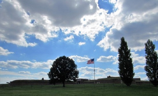
Our first stop of the morning was at George Washington Birthplace National Monument. As indicated by the name, George Washington was born here, and this was his home until he was three years old (when he moved to Ferry Farm). The home that Washington was born in was built sometime before 1718, and then enlarged between 1722 and 1726 – by the time Washington was born in 1772 it was a ten room mansion that the family had named Wakefield. Sadly, the home was destroyed by fire on Christmas Day 1779 and was not rebuilt, but there are other points of interest on the farm.

George Washington Birthplace National Monument

George Washington Birthplace National Monument

The Commonwealth of Virginia acquired the property in 1858 with the intention of restoring it, but the Civil War got in the way. The state donated the site to the federal government in 1882, but nothing was really done there until the 1920s. A historic preservation society raised the money to celebrate the 200th anniversary of Washington’s birth. They had a 1/10th replica of the Washington Monument built and placed at the entrance to the site, and also built a Memorial House.

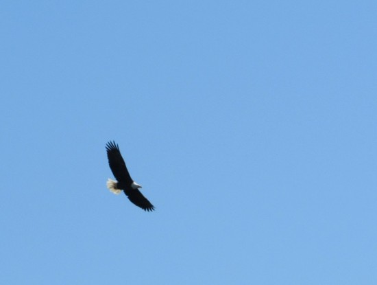
The site was established as a National Monument on January 23, 1930, and has an annual visitation of about 130,647 (in 2011).  When Jon and I walked up about 10:30 am, the place was empty. But we were greeted by a beautiful bald eagle who was sitting in a tree just above the Visitor’s Center. Talk about symbolism!

A Bald Eagle at George Washington Birthplace National Monument

A Bald Eagle at George Washington Birthplace National Monument

The Memorial Home is not intended to look like Washington’s birthplace home, as there are no surviving records to show what it looked like. Rather, it is supposed to look like a typical home from the period, constructed with hand-made bricks from the area, and furnished with period furniture. There is one tea table that is believed to have been in the birthplace home.

The Memorial Home - this is not what George Washington's birthplace looked like - it is an example of what a home of the period might have looked like.

The Memorial Home – this is not what George Washington’s birthplace looked like – it is an example of what a home of the period might have looked like.

We visited the home site and saw where the outline of the original home is marked with crushed oyster shells. Then we got to see the inside of the Memorial Home. We could tour it at our leisure, as the rooms are just blocked off with plexi-glass in the doorway so you can’t go inside. Even though it wasn’t an authentic 18th century, they did a good job of making it appear to be period.

The outline is the foreground is where George Washington's birthplace home stood.

The outline is the foreground is where George Washington’s birthplace home stood.


The interior of the Memorial House

The interior of the Memorial House

The ranger was pretty useless though – I asked her a couple of questions about the home, and she just kept saying that the home was not intended to look like the original home on the site. Even after I explained that I understood that, and I was really asking a more general question about homes of the era, she just kept repeating the same thing until I gave up. She was, without a doubt, the strangest park ranger I have ever encountered.  Sigh…

After seeing the Memorial Home, Jon and I set off to find an old cabin on the site. We had to cross a short bridge that lead over an inlet of Pope’s Creek, and then walk long a trail that led alongside the creek (Pope’s Creek is really more like a river, by the way). We saw a gorgeous Great Blue Heron out fishing for his breakfast.

Great Blue Heron at George Washington Birthplace National Monument

Great Blue Heron at George Washington Birthplace National Monument

We had just gotten across the bridge when Jon spied a snake in the brush next to the trail. He (Jon) stopped dead in his tracks and refused to go any further. He waited cautiously as I took a couple of photos and then announced that he was going back.  Apparently no cabin for me, unless I wanted to go it alone…

A black rat snake.

A black rat snake.

So back over the bridge we went, and suddenly, we saw a second snake swimming up to the bridge, and then under the bridge and out the other side! This snake was bright orange, and gorgeous! I was able to get some good photos of it too. At that point, Jon was very insistent that his exploring was over.

A copperhead! Swimming!

A copperhead! Swimming!

I did convince him that it would be safe to see the heritage sheep and cows on the farm though – they are so cute! The monument does a lot of educational programs with local schoolchildren, but thankfully we were there on a day that the farm was not crawling with kids.

Heritage cows pose with a 1/10th sized replica of the Washington Monument.

Heritage cows pose with a 1/10th sized replica of the Washington Monument.

As we were wrapping up our visit, I headed back into the Visitor’s Center to check out the exhibits, and to see if the ranger could ID my snakes. The first one was a Black Rat Snake, a non-poisonous snake that eats mice and rats and are considered very helpful snakes. However, they grow to about 6 feet long, so they freak a lot of people out. The one we saw was only about 2 feet long.

The second snake we saw was a copperhead! This snake is poisonous, although they aren’t really aggressive and prefer just to be left alone. From what I read, it is unusual to find them swimming, so I consider us lucky to see him!

George Washington Birthplace National Monument gets extra points for having fascinating wildlife! A Bald Eagle, a Great Blue Heron and two snakes, all in one visit!